- Author’s Introduction
- The Genesis of Rancho Viejo
- Rancho Viejo’s Geologic History and Paleonotology
- The First Residents of Rancho Viejo
- Lipan Apaches in Rancho Viejo
- El Camino de Barrio Atajo – Was Rancho Viejo on The Camino Real?
- 1600-1899 – “Unparalleled land Stealing”
- The Rancho Viejo HOAs – The Village
- The Rancho Viejo HOAs – Windmill Ridge
- So What About the Windmill?
- The Rancho Viejo HOAs – La Entrada
- Other Properties Within Rancho Viejo
- College Heights
- Water and Housing
Table of Contents
Author's Introduction
I first began writing essays in the early 1980s – at about
the same time that I discovered the joy of manually uprooting dandelions from
our Wethersfield, Connecticut lawn. I
always felt that the two avocations were somehow related but I have never been
able to fully understand or articulate the connection. A few years into my new literary hobby I took
a writing course at a local university.
We were assigned a short composition that told something about ourselves,
and our interest in writing. I no longer
have a copy, but the thesis was the coincident timing of these two activities –
with no attempt to explain why or how they were related. As I remember, my write-up was considered
quite profound. (I should mention that
“show not tell” was the workshop’s modus operandi – so in some sense ignorance
of the reason something happened was perceived as a somewhat of a virtue.)

For several
years I drafted mostly what I would call semi-humorous, semi-philosophical,
semi-gardening essays for my garden club newsletter and our local
newspaper. Then after retirement my wife
Marsha and I became involved in Wethersfield (Connecticut) Historical Societyand I began penning non-academic history articles for the organization’s
website – “tell not show” storytelling where the narrative is driven by facts
of the case rather than the free form, stream of conscious ramblings of the
author. Which is how I came to know such
former Wethersfield residents as Francesco Lentini – “The Human Tripod” and
“The King” of circus sideshow freaks and Thomas Hickey who was tried and executed
for conspiracy to kidnap General George Washington.
Marsha and
I now live in The Village at Rancho Viejo in Santa Fe, New Mexico. And I am continuing my avocation by
researching the history of Rancho Viejo – the land on which it sits, and its
occupants – from prehistory to today.
I am not a
trained academic historian – in college I was a Philosophy major, and then an
Information Technology professional for thirty-six years – so what follows is
not an academic treatise. I have tried to
be factually accurate and deeply appreciate the assistance and guidance of
David Rasinski, Community Association Manager, Rancho Viejo North Community
Association; Dr. Eric Blinman, Director, New Mexico Office of Archaeological
Studies; Ryan Flahive, Archivist, Institute of American Indian Arts; Pablo
Chattey; Oscar Rodriguez; Bram Meehan, son, “second reader,” consultant, a graphic design; and
especially Marsha without whom I never would have started writing and whose
“first reading,” edits, suggestions, and support continues to make it all
happen.
The history
of Rancho Viejo, like that of many other places, encapsulates in miniature the
characteristic qualities and features of the growth of Santa Fe, of New Mexico,
and of the Southwestern United States.
I hope that
you enjoy reading my version of that story.
— Jim Meehan
The Genesis of Rancho Viejo
Marsha and I now live in The Village at Rancho Viejo – a
Home Owner Association (HOA) Community in Santa Fe, New Mexico. When we first purchased our then sixteen-year
old house in September 2017, I mistakenly believed that Rancho Viejo was simply
a development made up of three HOAs – the other two being Windmill Ridge and
Entrada. When I began researching the
history of RV however I quickly discovered that the “Old Ranch” (as it would be
called in English) was in fact a 23,000-acre (39 square mile) parcel of land south
of I-25 in Santa Fe County, New Mexico – which, in addition to the three HOAs,
currently accommodates enterprises such as Santa Fe Community College; Santa
Maria de la Paz Roman Catholic Church; the Institute of American Indian Arts
(IAIA); and the Amy Biehl Community School; as well as several others, and more
empty space than I can visualize. The
magnitude of some of these southwestern land holdings boggles my provincial,
small town Connecticut mind. Our former
hometown of Wethersfield, for comparison measured 13.1 square miles including
.8 square miles of inlet cove and river water.
The size of our old Connecticut acreage would be a mathematical rounding error in the
southwest land equation. And as I continued my investigation I discovered that
Rancho Viejo, while three times the size of our former home base, was nowhere
near the biggest chunk of land in Santa Fe history.
During most of the twentieth century RV and its surrounding
real estate had been a succession of ranches the sizes and shapes of which ebbed
and flowed as a series of buyers and sellers purchased or sold entire
properties and parts thereof. The
current “Rancho” was purchased in 1981 by Adeline Meyer, Larry Meyer, Leland
Thompson, William (Bill) Kennedy and Fred Chambers operating as Rancho Viejo
Limited Partners. As far as I have been
able to determine this is the first use of that moniker in this area.
This chapter tells the story of Rancho Viejo’s genesis and
the immediately history of the land leading up to that purchase. Subsequent sections go back in time to tell
the story of the land and its occupants from pre-history up to RV’s creation –
and others discuss the evolution of the property from its 1981 establishment,
to its current state of development in 2018.
800 Head of Cattle and 10,000 Ewes on 115,000 Acres
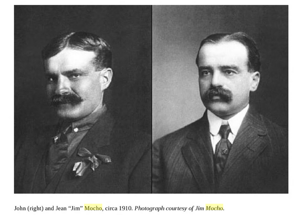
In the early part of the 1900s the RV land was a part of the
Mocho Family Ranch – owned and run by Jean Baptiste (“James”) and John Mocho
who were turn-of-the-century immigrants from the Basque Country.
In 1910 the Mocho brothers purchased a ranch in Encinoso
Lincoln County, in the foothills of the Capitan Mountains. “The initial ranch, formerly the Charles
Spence ranch, sat on 160 acres of deeded land, had two good springs and a
permit to graze two thousand ewes during summer months on Forest Service Land,”
according to Jim’s son Pete.
When New Mexico became a state the once open lands had some
new government controls placed upon them, which the Mocho brothers did not know
how to negotiate. “Their lack of
knowledge in such matters benefitted from political competition between the
Democrats and Republicans who had seen the territory become a state.” New Mexico’s first Governor was W. “Bill”
McDonald, owner of the neighboring Block Ranch – whom the Mochos regarded as a
competitor for the open land.

Pete Mocho continued, “In Lincoln County, the republicans,
under leadership of Mr. Andrew Huspeth, a lawyer, and Mr. Charles Spence, a
banker, seized on the opportunity of limiting Governor McDonald’s expansion of
his Block Ranch by taking Dad and uncle John to Santa Fe and helping them file
on state range land and against Governor McDonald’s expansion of his Block
Ranch…[the Mochos] were the only landowners near Governor McDonald who were
authorized to claim a commensurate righ to the new state lands.” As a result
the Mocho Ranch grew to 160,000 acres of choice land.
Other ranchers came in and settled the land between Mocho
Ranch and Block Ranch – among them Thomas Shoemaker whose daughters Nora and
Ora married John and Jim Mocho in 1914 and 1916 respectively. The two families soon outgrew the 1890s
u-shaped house on the ranch that they shared – and over a four-day period in
1917 Jim and John Mocho “ sold the whole operation on Monday for cash to Pete
Etchevery and George Walker.” The ranch
had, by then, grown to 800 head of cattle and 10,000 ewes, which brought $80 a
head and $14 each.
James Mocho then purchased the “Bonanza Grant” in Santa Fe,
and John joined him in raising sheep and cattle on the family ranch. According to an article on newmexico.org, “The
chain of title is confused, but the lands, sometimes called La Bonanza, Bonanza
Creek, Cerrillos Ranch, or old Cerrillos, as well as the recorded grant names,
were in the hands of the Padilla and Rio Grande Livestock Company when
purchased by the Mochos.” The combined owned
land and leased land that comprised the Mocho sheep and cattle operation at one
time apparently totaled 115,000 acres.
The article continues, “Jim Mocho [John’s son] says that his
father built many of the fences in the Rancho Viejo area and tried to convince
others to do so as well, once buying an entire railroad car full of barbed wire
in Albuquerque.”
The Mocho homestead was broken up and sold off in part due
the effects of Great Depression, and partly due to the decrease in open
grazing land caused by public spaces being given over for housing and highway
department usage. In 1951 part (or
possibly all) of the Mocho family ranch plus, over time, three other properties
– the Dody, Morrow and Calvin holdings became the Jarrett Ranch.
According to the June 2006 “San Marcos District Community
Plan” – “The remaining area in the district is residential/agricultural land
ranging in lot sizes varying from less than an acre to several hundred acres.
The settlement pattern is a result of the breakup and sale of several large
ranches over time, the largest of these being the Jarrett Ranch.”
“By the Mid 1970s the isolated ranch house was mostly a
thing of the past. While still very rural in nature, the San Marcos district
had probably picked up another fifty or sixty families. Subdivision, in all of
its guises, was rampant, although building was not. The giant Jarrett ranch was
split in two after the death of Mr. Hughes, with Rancho Viejo Partnership
purchasing the eastern half of the ranch.
Both halves however, continued to be run as working cattle ranches.”
Value Unclear, But Hefty
Rancho Viejo itself was formed from a portion of the 36,000-acre
Jarrett Ranch, which was located between Santa Fe and Madrid, south of I 25,
east of La Bajada, and west of US 285. Richard “Jim” Jarrett and his wife Tillie
bought the property in 1951 and then Jim died in a traffic accident in 1957
after which the entire spread went to his wife.
Tillie married an Albuquerque Chiropractor named Sam Lord shortly after
which she died of cancer leaving the ranch to her sister Sue Hughes who soon
after also died of the same disease. The
land then went to Sue’s husband Glen and son Bobby who decided to sell some of
the land to pay the inheritance taxes.
In his Memoirs Larry Meyer writes, “Reporter Steve Terrell
wrote an article for The New Mexican newspaper when we bought Rancho
Viejo. The title was ‘Three ‘Old
Republicans’ Buy the Ranch,’ and in it Terrell implied that we were all
Texans. Leland is from Kansas
originally, and I am from California. In
the article, Terrell called us carpetbaggers, despite the fact that, at the
time, I think Leland had been here for about 25 years, and I had been here for
30 years! Fred Chambers indeed was from
Texas, but Fred didn’t take part in the day-to-day decisions. It was more or less Leland and I who managed
the operation.”
In Santa Fe Larry Meyer had established and run the L.E.
Meyer Company, originally a mechanical contracting firm, and later a real
estate development company in 1951. He
and his wife, Adeline, were well known for their generous support of higher education,
the Santa Fe Opera, Santa Fe Garden Club, and other community efforts.
Leland Thompson was named one of “The 25 Richest People in
New Mexico” by CROSSWINDS, “New Mexico’s Largest Alternative Newspaper” in
October 1996 – “LELAND THOMPSON, Santa
Fe. Transplanted Texas oilman owns with partners lots of land around Interstate
25. Value unclear but hefty.” In Midland
Texas Thompson, Chambers and Kennedy were involved in the oil business with
George H.W. Bush in the 1950s. Leland
and “HW” were both “wildcatters,” and Thompson reportedly gave a young “W” Bush
his first ride in a small airplane. Leland
Thompson was also a founder of Santa Fe Preparatory School, and involved in a
major way in the establishment of the Santa Fe campus of St. John’s College.
The San Marcos Plan goes on to say, “Most of the [Rancho Viejo] holding continued
as a 200 to 400 head cattle ranch leased to Mr. Henry McKinley. The partners
concentrated their development efforts in the northern sections (outside the
San Marcos District).” Cattle farming
ceased as in the mid-1980s as new land use codes were enacted.
Prior to the development of the Rancho Viejo HOAs, RVLP donated
the lands for the establishment of Santa Fe Community College, Santa Maria de
la Paz Roman Catholic Church, and the Institute of American Indian Arts (IAIA) as
well as The Turquoise Trail Elementary School and the County Fire Station across
from San Marcos Feed Store.
There
is more information on the five members of Rancho Viejo Limited Partners in the
chapter by that name. But my quest for a
history of Rancho Viejo will continue, as, among other things, I attempt to:
learn the actual boundaries of the Mocho Ranch; find out more about the Jarrett
Ranch, including its dimensions; and still possibly trace RV’s chain of
ownership back to the original Spanish Land Grant(s).
Recently Marsha and I attended a talk by Abiquiu New Mexico
author Lesley Poling-Kempes about her latest non-fiction work Ladies of theCanyons – “intrepid women whose lives were transformed in the first decades of
the twentieth century by the people and landscape of the American Southwest.”
She talked about the difficulty of researching the history
of people who are not famous – such as the four main subjects of her book. Stuff just is not written about them. But in this case one of the Ladies, Natalie
Curtis, was a friend and professional acquaintance of President Theodore
Roosevelt and is mentioned in works about him – e.g. introducing him to the
Hopi Indian Snake Dance at Walpi Arizona in 1913.
This absence of source material also seems to be the case
with looking into the history of the land on which our property sits. There was no “Battle of Rancho Viejo Hill” with
tales of Rough Rider daring-do for historians to recount. Then, when some documentation is uncovered it
sometimes contradicts other accounts of the same event. But that is what makes researching fun – even
at the amateur level.
As Sir Winston Churchill describes it, “History with its flickering
lamp stumbles along the trail of the past, trying to reconstruct its scenes, to
revive its echoes, and kindle with pale gleams the passion of former days.”
Additional Note: Bonanza Creek Ranch – “one of the premiere [movie and TV filming] locations in the western United States” and about twelve miles south of our address (as the raven flies) was was also acquired from the Jarrett Ranch in the 1980s. The film “Cowboy” starring Glenn Ford and Jack Lemmon was the first movie filmed here in l958. 1,200 Corriente steers were brought up from up from Mexico to use for the cattle drive scenes.
Sources:
Windmills and Dreams: A History of the Eldorado Community
and Neighboring Areas
Eldorado Community improvement Association
New Mexico in Maps, University of New Mexico Press
The Memoirs of Larry Myer
June 2006 “San Marcos District Community Plan”
Ladies of the Canyons, Lesley Poling-Kempes, University of
Arizona Press
Capitan, New Mexico: From the Coalora Coal Mines to Smokey
Bear, Gary Cozzens, books.google.com/books
Rancho Viejo's Geologic History and Paleontology
“The desert holds the memory of ocean tides”
Marsha and
I have always felt most at home either in dry, barren areas of land, or on
sandy beaches. That is why we mostly
vacationed in either the deserts of the American southwest or at the ocean
shores of North Carolina. And now we
have moved to Rancho Viejo, a community located several miles outside the city
limits of Santa Fe New Mexico, near the Galisteo Basin – one of the most
interesting geological, archaeological, and historical regions in North
America. Absolutely the right place for
us, but still there is that “either or” feeling.

Then at a
Book Art exhibit of Santa Fe Book Arts Group I read the poem “Once There Was an
Ocean Here” by Liz Paterson with the phrase, “The desert holds the memory of ocean tides,”
which brought me back to an Elderhostel (now called Road Scholar) educational trip to the Chihuahuan
Desert in Big Bend National Park that we went on in 1998.
One of our
instructors was a self-trained paleontologist named K – a surveyor by training
and vocation who had come to the area a decade earlier on a job assignment; became
obsessed with the paleontological possibilities of, what he would say is, “one
of the most complete pictures of a prehistoric ecosystem known anywhere on
earth,” and with the solitariness to pursue that fixation; and just never left.
The desert can do that to you.
We went out
on a dig for fossils with K who, like the avaricious gold seekers in the movie Treasure of Sierra Madre, was unwilling to let us rank amateurs actually lay hands on
any of the prehistoric leftovers that we came across. (The desert can do that
to you also.) Later on we visited his
retired yellow school bus “museum” jam-packed with osteo-relics for a hands-off
tour.

The fossil
record at Big Bend includes artifacts ranging in time from the Age of Reptiles
to the Age of Mammals, beginning about 100 million years ago when a huge sea
covered most of what is today the midwestern part of the United States. Many of these marine fossils can be found in
the remaining sea layers of limestone known as the Boquillas Formation, including
a 30-foot long sea-dwelling reptile known as Mosasaurus.

Some
quick
Internet searching revealed that during what is called the Pennsylvanian
Period
(323 to 299 million years ago) almost sixty percent of New Mexico was
covered
with shallow seas – including Santa Fe. (Also known as Upper
Carboniferous or Late Carboniferous, Pennsylvanian is named after the
U.S. state of Pennsylvania where the coal-productive beds formed during
this age are widespread.)

Subsequent
mountain-building activity pushed up the basins and strata that had been left
behind by the sea to form what is now called the Sangre de Cristo Mountains –
about fifteen miles to the northeast of our address as the raven flies, and
clearly visible from the walking trail at the end of our street. On the Santa Fe side of the “Sangres” you can
discern at least one cycle of sea level change, starting with beds of marine limestone
deposited in a clear, well aerated, sub-tidal environment, as well as
interbedded limestone, and mudstone – plus ripple marks on sandstone that
document the shifting tides of the sea.
Small numbers of Pennsylvanian Trilobites (a fossil group of extinct
marine arthropods) have been found in the Santa Fe area.

This
southernmost sub-range of the Rocky Mountains – named “Blood of Christ” in 1719
by the Spanish explorer Antonio Valverde y Cosio after being impressed by the
reddish hue of the snowy peaks at sunrise, also known as alpenglow – is home to
the Santa Fe Ski Basin (10,350 ft. – 12,075ft) whose snow (albeit mostly
manmade in recent years) can be either an autumn harbinger of the winter to
come or a spring reminder of the winter past.
Geologically
these peaks are composed of granite that has been “metamorphosed” (i.e. altered
by heat and pressure). Granites are
formed by molten magma that never quite makes it to the surface and cools
slowly to form solid rock. After
cooling, some of these stones are subject to additional intense heart and
pressure, which causes some of the minerals within them to line up in very
faint bands on the surface of the rock.
Called “gneiss” (“nice”) many of these stones can be found along nearby
U.S. Route 285 and, according to the book “Windmills and Dreams,” are estimated
to be more than one billion (with a “B”) years old.
If we take
the same the trail in another direction Marsha and I can see the Jemez
Mountains to our west – the cause of our dazzling daily sunsets. The highest point in the range is Chicoma
Mountain at an elevation of 11,561 feet.
The Jemez (or Tsąmpiye'ip'įn in Native American Towa) are made up of
several volcanoes and the volcanic fields that erupted from them. The last explosion was about one and a half
million years ago and spewed out 150 times the volume of ash as the 1980 Mt.
St. Helens discharge. This eruption also
caused the formation of Valle Caldera (one of the largest caldera features on
the planet) about 60 raven flight miles to the northwest of Santa Fe.

Between our
neighboring “census-designated place” (CDP) of Eldorado and the Jemez Mountains
lies the Rio Grande Rift. A rift is a
long thin zone of the earth’s crust where, due to plate tectonics, the
continent is attempting to pull apart.
The Rio Grande Rift extends from southern Colorado to just over the
border with Old Mexico (a designation I never would have felt the need to use
in our prior home of Connecticut). The
Rio Grande fissure is considered a “failed rift” because instead of seawater
like the “successful rift” that formed the Red Sea, it merely contains sediment
and several layers of down-dropped rocks.
The other
major prominence that creates the visual border of the high desert land around
our community are the Sandia Mountains (Southern Tiwa name posu gai hoo-oo,
"where water slides down arroyo") located on the eastern side of the
city of Albuquerque, about thirty-five raven or car miles to the south. Sandia means watermelon in Spanish, which is
popularly believed to refer to either the reddish color of the mountains at
sunset, or to the profile of the mountains with a zone of green conifers along
the top suggesting the rind of the large melon-like fruit. Another theory is that in 1540 the Spanish named
the Indian pueblo near the range “Sandia” because they mistakenly thought the
squash grown there were watermelons.
They then ascribed that same name to the mountains. Native Americans also called it “Bien Mur” or
“big mountain.”

The Sandias
measure about seventeen miles long (north-south) and vary in width from four to
eight miles with a height of 9,700 feet to 10,400 feet. Today a 2.7 mile long Aerial Tramway ascends
4,000 feet in fifteen minutes to the top where hikers can explore the many trails. The High Finance Restaurant, formerly at the
peak, is currently (2017) closed “as part of a larger plan to replace the aging
structure with a new building and new concept,” according to the Albuquerque
Journal.
Geologically
the west side of Sandia contains Precambrian aged rocks in the lower part of
the mountain and (most curiously) a thin series of layered limestone that began
as mud at the bottom of a warm shallow sea.
In the
foreground between Ranch Viejo and these three mountains are a number of
smaller ranges, and a “cuesta”. Cerro Pelon
(“Bald Rock”) is a formation with one steep side and one sloping side that was
created by the abrupt intrusion of molten rock through two different
sedimentary rock formations. To the
cuesta’s right the Manzano Mountains, with a Precambrian configuration like the
Sangres, form the eastern backdrop for the Rio Grande River near the town of
Belen.
The San
Pedro Mountains and the Ortiz Mountains are similar in geology to the Sangre de
Cristo but much younger having been formed about 30 million years ago. The Ortiz were the site of the first American
Gold Rush in 1820, leaving a line of talus (debris rock) from the mining
operations. 350,000 ounces of the
precious metal have been removed to date.
Los Cerrillos (the “Little Hills”) are made up of cooled magma and
turquoise, which has been mined by the Native Americans for over a thousand
years. European mining claims later led
to a series of owners, including New York City’s Tiffany and Company. In the 1880s the market value of turquoise
was comparable to that of gold.


(Herculano Montoya at the Tiffany mine (1937). Palace of the Governors Photo Archives.)
While these pinnacles are visible all of the time, our perception of them is sometimes less than crystal clear. Early morning haze, low-hanging clouds, smoke from fires in California, distant falling precipitation, or blowing dust from high winds in March and April sometimes veils, or totally hides, each layer of mountain behind its own ghostly curtain of translucent (or opaque) mist. And, when you are at ground level, they are not always cleanly delineated from each other, as they would be on a map. Especially since, as we traverse the area, we keep coming at them from different angles. As a result Marsha and I cannot yet definitively identify all of the foreground summits. So we have to keep exploring. Which, in my mind at least, just makes our interesting geology even more interesting.
Even before
we moved to the Southwest Marsha and I knew we would deeply miss the sights and
sounds of the white sands and crashing waves of what Carolinians like to call
the Crystal Coast – as well as that sense of calm and belonging that we got
from wading in the waters of the Atlantic, and feeling the sea salt drying on
our tan sunbaked skin.
So it is
comforting now to know that we don’t really have to fly 1,800 miles east to
recapture that feeling. Instead, all
that we have to do is dig down about 300 million geological years beneath our
feet. No more “either or.”
The desert – and mountains – can do that to you.
“A census-designated place (CDP) is aconcentration of population defined by the United States Census Bureau forstatistical purposes only. CDPs have been used in each decennial census since 1980 as the counterparts of incorporated places, such as self-governing cities, towns, and villages, for the purposes of gathering and correlating statistical data. The boundaries of a CDP have no legal status.” (Wikipedia.com)
The First Residents of Rancho Viejo
Marsha and I never met the person from whom we bought our home in the Village at Rancho Viejo in Santa Fe, New Mexico. We knew her name of course – and a little bit about her from the way she furnished and decorated her house. We also are learning the names of other previous occupants from the catalogs and solicitations that still arrive for them in our mailbox. It is just human nature to want to know something about those that came before you. To discover who the very first residents of our property were however required some serious research.
But first a brief note on date terminology. In researching this paper I came across several conventions for expressing dates. There is of course the BC (Before Christ) & AD (Anno Domini) nomenclature that many of us grew up with – which was replaced in scientific and academic circles in the 1990s by BCE (Before Common Era) & CE (Common Era) because they “do not presuppose faith in Christ and hence are more appropriate for interfaith dialog.”
But first a brief note on date terminology. In researching this paper I came across several conventions for expressing dates. There is of course the BC (Before Christ) & AD (Anno Domini) nomenclature that many of us grew up with – which was replaced in scientific and academic circles in the 1990s by BCE (Before Common Era) & CE (Common Era) because they “do not presuppose faith in Christ and hence are more appropriate for interfaith dialog.”
In
addition, in the Archaeological writings that I was reading there was YBP
(“Years Before Present Time”) – instead of X number of years ago. And my own personal favorite “uncal RCYBP” (“uncalibrated
Radiocarbon Years Before Present”.) In
this paper I used the BCE & CE convention because most of the quotes that I
used already contain those abbreviations.
“I sure hope we run into some bison”
When Pedro
de Peralta came to Santa Fe in 1610, he and his fellow colonists were probably
aware that they were not the first people to live here. The area in fact already had a name – “Ogapoge” (“down at the Olivella shell-bead
water”) – given to it by the local Tewa-speaking Indians who had arrived on the
scene in the late 1300s or early 1400s CE.
And they themselves were preceded centuries earlier by a groups of
people referred to archaeologically as the “Paleoindians” and the “Archaics.”
12,000 years ago the landscape and climate of
Santa Fe were quite different than today.
According to Jason Shapiro in his book “Before Santa Fe”, “The area around Santa Fe would have been
heavily forested with varieties of spruce, pines and conifers, interspersed
with grasslands, with a climate much like that in British Columbia or other
parts of the northwest today except that these Late Pleistocene environments
were more complex with a mixture of both existing and extinct species.” The trend toward warmer and drier began
around 9,500 BCE and became what is basically today’s landscape and climate
around 5,000 BCE
Around 12,000
years ago the people referred to as Paleoindians or Paleoamericans entered, and
subsequently inhabited, the Americas – and New Mexico. These hunter-gatherer people were spread over
a wide geographical area, resulting in wide regional variations in lifestyles.
However, all the individual groups shared a common style of stone tool production
– the so-called lithic reduction method.
Paleoindians,
including those in the Santa Fe area, would have hunted such game as mammoths
and mastodons; bison that were as much at 1,500 pounds heavier (almost twice
the size) than today’s species; caribou, elk and prong-horned antelope; ground
sloths, one-humped camels and glyptodonts (an extinct subfamily of large,
heavily armored armadillos); as well as grizzly bears and mountain lions.

The number
of Paleoindian sites that have been discovered is quite small, probably because
of the destruction caused by natural processes like flooding, freezing, erosion
and (what Shapiro calls) “the underappreciated actions of plants and
animals.” Plus – “if
we make the reasonable assumption that contemporary and historically identified
hunting and gathering societies are acceptable models for Paleoindians, we are
talking about small mobile bands of somewhere between fifteen and forty
people…[in short] there were not very many Paleoindians, they left relatively
small amounts of stuff in the archeological records, and much of the material
that they created and used has not been preserved.”

(Paleoindians hunting a glyptodont)
Still fifty-nine sites have been identified in the Albuquerque Basin, fifty miles south of New Mexico’s capital city. And several miles west of the Santa Fe the Caja del Rio site contained evidence of projectiles and tools made in the Clovis (11,500 – 13,000 years ago) and subsequent Folsom, Plano, Midland, Angostura and Cody/Scottsbluff time periods – indicating this site’s desirability as a camping place for a period of time in excess of 4,000 years
In a
November 20, 2015 Albuquerque Journal
article Santa Fe Assessor Gus Martinez is reported as saying that, “of the
30,451 residential homes within the city limits of Santa Fe, 4,932 have
out-of-state addresses on their property tax bill. That works out to be about
16.2 percent, or close to 1 in 6.
Outside the city limits [where Marsha and I live], 2,485 of the 22,283
homes in Santa Fe County, about 11.2 percent, are owned by out-of-staters.”
Same as it
ever was, according to the above-cited Jason Shapiro. “This contemporary phenomenon is not the first
instance of transient, seasonal, and part-time residency in Santa Fe, but the
belongings of the early seasonal residents were fairly minimal – yucca fiber
sandals, spear throwers and stone-tipped darts, a few stone or bone tools, some
baskets, cordage-woven nets, and maybe a rabbit fur blanket or two. Several thousand years ago, these few things
were enough to make it in Santa Fe.”
"I know exactly where the
antelope herd hangs out."
The next wave of short-term residents are referred to by Archaeologists as “Archaic” hunters, gatherers, and foragers – and they lived in the Santa Fe area about 1,500 to 1,600 years ago – the Paleoindians having left the scene some 6,000 years earlier. The Archaics’ food menu was no longer large herd animals, which were now less available due to climatic changes, but instead smaller animals such as antelope and deer – and a wider assortment of wild plants.

Again Jason
Shapiro: “all Archaic foragers relied to a greater or lesser degree upon
mobility. The earliest hunter-gatherers
seem to have been more dependent upon ‘encounter based’ strategies…(‘Gee, I
sure hope that we run into some bison.’)
As people became more familiar with smaller territories they modified
this approach…Later Archaic groups were very familiar with all aspects of their
locales and knew what plants and animals would most likely be available at
specific locations during particular times of the year (‘I know exactly where the
antelope herd hangs out.’)”
The Archaic
sites around Santa Fe range in age from 7,000 to 1,500 years ago with one of
the most significant being La Bajada near Tetilla Peak about fifteen miles
southwest of downtown Santa Fe. Camps
have been discovered to the northwest of the city in Las Campanas and south in
the Tierra Contenta subdivision. Others
have been found near the Cochiti Reservoir.
“People living near Santa Fe could have shifted their temporary residential camps from the riparian areas near the Rio Grande and lower Santa Fe Rivers, where fish, turtles, and water-loving plants such as cattails and arrow-weed would have been available in the spring, through the grassland savannah on the broad plains west of the city, where Indian grass, amaranth, dropseed, goosefoot, and other small seed plants provided early summer greens and, later in the summer, ripe seeds. In the fall, people would have moved into the pinon-juniper woodlands located to the north and east of the city for the collection of pinon nuts, cactus fruits, and juniper berries, and finally into the higher Ponderosa pine and mixed conifer forests of the Sangre de Cristo mountains for fall deer and elk hunting. Finally they would return to the lower valley of the Santa Fe River near the Rio Grande.”
The next
cultural periods and sets of locals reflect the change in lifestyle to what is
sometimes called the “triumvirate of Puebloan traits” – agriculture,
sedentariness (the practice of living in one place for a long time), and
village-scale organization. During this
period 400/600 CE to 1325 CE Pueblo life in Santa Fe developed such that (according to Shapiro):
“If you climbed Atalaya peak [in southeast Santa Fe] eight hundred years ago and had a decent pair of binoculars, you could probably pick out, or at least see the smoke from, most of the Coalition Period pueblos that occupied various parts of the city. Right in the center of downtown was El Pueblo de Santa Fe, as well as a pueblo on Fort Marcy Hill. On the south side of town one could see Mocho and Upper Arroyo Canyon and possibly Los Alamos Pueblo located several miles southeast of Santa Fe along state route 285. Continuing on the west side of town where Agua Fria Street and the Alameda bracket the Santa Fe River, you could find several settlements beginning with the largest pueblos, Agua Fria Schoolhouse and Pindi, and continuing with several others positioned like beads on a string for three miles along the river. These were not the almost tentative pueblos that appeared during the Developmental period but were the successful results of a couple hundred years of maize-fueled village growth…Pindi had no less than 175 rooms…and Agua Fria Schoolhouse…upwards of 500.”
El Pueblo
de Santa Fe (possibly settled as early as 400 CE) was located at the site of
the new Convention Center. And the Fort
Marcy settlement included the large village of Kwapoge whose eight-foot trash
heap indicates principal occupancy took place 1050 – 1150 CE. The refuse heap
also included samples of Red Mesa black-on-white pottery from the Cibola Region
near Gallup, NM suggesting a long-distance trade connection.
One
identifying marker that distinguishes this new Coalition Period pottery from
Developmental is the use of organic, carbon-based paint (instead of
mineral-based) on what is now called Santa Fe black-on-white pottery.

By
archaeological convention 1325 CE marks the beginning of the Classic Period
“when virtually all of the inhabitants of the northern Rio Grande region gave
up small and medium-sized villages in favor of big settlements.”
South of
Santa Fe the Arroyo Hondo Pueblo, for example, “started out as a 100-room
hamlet in about 1300. Within the next 30 years, it exploded into a 1,000-room
pueblo,” according to Douglas Schwartz of School for Advanced Research as,
reported in the Santa Fe New Mexican
January 29, 2016. Schwartz was the
Principal Investigator on the 1971 excavation of the site and developer of the arroyohondo.org
website.
Click here
for Arroyo Hondo Pueblo animation. http://dennisrhollowayarchitect.com/ArroyoHondo.html
So,
throughout the prehistory of Santa Fe –
from the Paleoindians, to the Archaics, to the Puebloans – Native Americans
have hunted, foraged, and lived in the city and some of its surrounding
areas. But other than inference of likelihood
– is there any real evidence that these early indigenous people actually set
sandal-clad foot on the 23,000 acre Rancho Viejo property?
“A lovely little pueblo.”
In my
research as to whether Prehistory Indians were actually present in Rancho
Viejo, I found references to two reports mentioning Rancho Viejo by name and archived
at the New Mexico Office of Archaeological Studies: "An Archaeological
Inventory of 302.5 Acres, Rancho Viejo Phase I” and "Request approval to
vacate a platted [planned] archaeological easement on 118.670 acres within
Rancho Viejo.”
Ian Norrish
cited the second study in his column in the August 2014 “Rancho Viejo Roundup” newsletter. At that time he was able to access the paper
online and he reported on it in his article.
“At the
request of Rancho Viejo de Santa Fe Inc., the prior developers of Rancho Viejo
1 and 2 the archaeologist of the Museum conducted an archaeological inventory
of an area of Rancho Viejo.”
They found
that the area was not “archaeology significant” and allowed the developer to
proceed with construction. However the
report did go on to say, “The site(s) represent a important aspect of human
occupation of the Southern Santa Fe and Eastern Galisteo River basins…[and]…
reflect occupations during the late Archaic to Basketmaker II periods (800 BC.
to A.D. 400), the Coalition and early Classic periods (A.D. 1200 to 1425), and
the late Territorial to Statehood periods (A.D. 1880 to 1941.”
Ian Norrish
concludes that he no longer considers himself to be just “an ‘old guy’ from
back east settling into retirement in Santa Fe, but a modern time-traveller
hiking and biking these ancient lands.”
The paper
is no longer online, so I requested both reports from the Office of
Archaeological Studies. However current New
Mexico State Statute, enacted some years after Ian Norrish’s online research, prevents
the OAS from sharing such data with the general public in order to keep the location
of unprotected sites private – and thus not provide a map to treasure-seekers
who might plunder them. Also these
papers seem to concern themselves with the 6,000 acres of Rancho Viejo now
occupied by its HOA communities, and therefore might not have answered
questions about the entire 23,000 acre Rancho Viejo property, which is my area
of interest for this chapter.
Then –
while in the back-and-forth process of setting up a meeting to discuss my query
with Dr. Eric Blinman, OAS Director – I came across a November 1995
"Interview with Four Archaeologists", published in "Windmills and Dreams: A History ofEldorado and Neighboring Areas."
The Census Designated place of Eldorado at Santa Fe abuts Rancho Viejo
land at Eldorado’s north and west borders – so perhaps historically and
archaeologically they have some things in common. And Dr. Blinman was one of the quartet of
scientists who were asked if pueblos existed in the Eldorado area.
Stew
Peckham, also part of the panel, replied first, “…there was the one called
Pueblo West which was a little more west of [excavation site] LA 8 which was
really off the old road of Eldorado, the original first entrance.”
And Eric
Blinman continued, "It is very well
hidden, that is one reason why it has not been damaged very much by vandalism,
it is in excellent shape. It is a
lovely little pueblo and will be part of Rancho Viejo subdivision when they develop
that. There is no choice to preserving
it. It is such a nice pueblo, they want
to preserve it. Right now they have the local residents being site stewards of
it…keeping track of who comes and goes.
The earliest possibilities of anyone being out there would probably be
as early as 12,000 years ago with hunters chasing after mega-fauna in the
area….Eldorado would be a transitory gathering ground."
Dr. Blinman
and I met on a Sunday morning at his office in the Center for New Mexican
Archaeology on Caja del Rio Road in Santa Fe.
The short
answer to the hunter/gatherer/resident question is that, what is now Rancho
Viejo was one part of the “mosaic of resources” in the Santa Fe area utilized
by the Prehistory Indians for food and housing.
And Pueblo Wells, better known (and searchable) as Chamisa Locita, was
in fact the first housing community in Rancho Viejo predating Marsha’s and my
home in “The Village” by over 600 years.
He directed
me to the “Galisteo Basin Archaeological Sites Protection Act" website, where it
said, “Chamisa Locita (LA 4) is a Coalition-period [1200 – 1325/50 CE] residential
complex first recorded by Nels Nelson in 1914. The site consists of a long,
primary east-west mound with four additional mounds abutting it perpendicularly
to the south. This roughly E-shaped configuration defines two primary plazas
sharing the long east-west mound. These plazas are partially enclosed by
additional detached mounds to the south. The detached mounds may define
additional, but more informal plaza areas.”

Nelson’s
excavation showed that, “the long east-west roomblock was actually continuous
and common to both plazas. Nelson depicted 16 roomblocks, and the scale of
Nelson's map suggests that there were between 280 to 300 rooms. Several roomblocks were probably two stories
tall.”
And, according
to a 2003 University of New Mexico Archaeology paper, “A circular depression
represents a probable kiva. The multistoried pueblo covers a 350 ft north-south
by 450 ft east-west area. Several nearly enclosed plazas are represented,
contrasting with the linear layout of Pueblo Alamo. Nelson (1915) excavated 44
rooms, including a room with walls decorated with red painted lines and thin
zigzag motifs. The Santa Fe Archaeological Society (1959) dug three additional rooms.
Outside of these poorly documented projects, no recent excavations have been
conducted at this important Coalition period pueblo. The ceramic artifacts
suggest an occupation between A.D. 1200 and 1400 (Dickson 1979:118). Chamisa
Locita and Pueblo Alamo are contemporary Coalition period village complexes,
but Pueblo Alamo was apparently abandoned before Chamisa Locita.”
Easy access
to water was the major need for any form of permanent housing – then as well as
during the 20th century development of the Rancho Viejo HOA
communities. The 2003 UNM Archaeology
paper addresses that issue for Chamisa Locita.
“The
spring-fed floodplain areas of the main Arroyo Hondo canyon seem to offer the
greatest agricultural potential. Additional springs are found at Pueblo Wells
in Canyon Ancho, 1 km west of Pueblo Alamo and
at the spring-supported Chamisa Locita
(LA 4), another large Coalition period pueblo. A windmill currently taps
the spring, and the water is used for grazing purposes at or near Arroyo Hondo
Pueblo slope.”

Pueblo Wells was occupied from
1200 – 1400 CE, (as mentioned above) a
time in which many similarly sized “smaller” pueblos were established in this
area by several different groups of people, from various tribes, speaking
various languages, and trying to live together in mutual tolerance despite
different ideologies, interests and native tongues. The formation of, and movement to, the much
larger eight Galisteo Basin Pueblos (Galisteo, San Cristobal, She, Colorado,
Largo, Blanco, San Lazaro, and San Marcos) indicates the success of this
attempt at coexistence – with the inhabitants of Chamisa Locita relocating to
the San Marcos Pueblo near the current town of Cerrillos.

One reason
for this ability to coexist might be the accretive nature of Pueblo Indian
culture – “the process of growth or increase, typically by the gradual
accumulation of additional layers or matter.”
Dr. Blinman said to think of the Pueblo Indian belief system as like an
onion with the core beliefs in the center and additional layers added as they adopted
new rituals and beliefs. The innermost
layer of the Tewa tribe, e.g., is the moieties – “each of two social or ritual
groups into which a people is divided.” For others such as the Keresan it would
be the Medicine and Clown Societies. The outer layer of all New Mexican Pueblo
Indian “onions” is the Catholicism, which was forced upon them by the Spanish
colonizers. This ability to add on
beliefs without sacrificing or even modifying existing ones allows today’s
Puebloans to legitimately profess to be both Tewa and Catholic in
religion. And, perhaps in the past, to
coexist more easily.
Chamisa
Placita is located near the north-south border of Rancho Viejo and Eldorado,
within walking distance of the Eldorado Community Center, where currently it is
watched over by volunteers from the nearby Alteza Estates.
Sources:
Before Santa Fe:
Archaeology of the City Different, Jason Shapiro, Museum of New Mexico
Press; August 16, 2008
Windmills and Dreams:
A History of the Eldorado Community and Neighboring Areas,
Eldorado Volunteers, Eldorado Community Association (1997)
Lipan Apaches in Rancho Viejo
“They all started out together”
“They all started out
together. But soon they began to play
games. The others did not want to wait
and went on…At different places various groups wanted to remain, and they broke
away from the main group…Finally some reached the center of the earth. These are the Jicarilla Apaches.” Morris Opler, American Anthropologist

Throughout the prehistory of
Santa Fe – from the Paleoindians, to the
Archaics, to the Puebloans – Native Americans have hunted, foraged, and lived
in the city and much of its surrounding areas.
The modern Santa Fe property area that is the subject of my immediate
research – Rancho Viejo – was one part of the “mosaic of resources” utilized by
the Prehistory Indians for food and housing.
Better yet for my purposes, Pueblo Wells, better known as Chamisa
Locita, was almost certainly the first housing community in Rancho Viejo – predating
Marsha’s and my neighborhood by over six centuries.
Years after
these prehistoric visitors and inhabitants occupied this land, Indians such as Comanche,
Ute and Apache hunted, gathered, lived, and raided throughout northern New
Mexico and Santa Fe. However finding similar
evidence for the presence of any of these nomadic bands in or near our present
home area has proven even more difficult than it did for their pre-history
forerunners – who themselves “left relatively small amounts of stuff in the
archeological records, and much of the material that they created and used has
not been preserved” according to Jason Shapiro in his book Before Santa Fe.
But artifacts are not the only way to
reconstruct the comings-and-goings of Native American tribes. Unlike the Paleoindians and Archaics, current
indigenous people – such as the Athapaskan speaking Lipan Apache – have a
strong oral tradition from which to put forth what anthropologist B. Sunday
Eiselt calls “legitimate claims to specific places”
In her book
Becoming
White Clay Eiselt argues that “archaeological materials need not be present
in a given area to establish it as Apache cultural space…Apache people are
challenging archaeologists to interpret their materials from an Apachean and
Athapaskan perspective, one that privileges their legitimate claims to specific
places regardless of the presence or absence of material remains.” Apache (and Navajo) site identification will
continue to be “a perennial challenge given the ephemeral nature of Apache and
Navajo settlement and land use.”
Originally
local to Alaska and Northwest Canada, some sources place the arrival of Athapaskan
speaking Apachean people in the southern plains of the United States as early
the 1000 A.D. The result of this great
migration is seen in the three geographic groups of that make up the Athapaskan
language family: the “Northern” occupy an area from Alaska and Northern British
Columbia south to the northern potion of the Canadian Prairies provinces; the “Pacific
Coast” range from Oregon to northern California; and the “Apachean” or “Southern”
includes the Navajo, Chirichua, Western Apache, Mescalero, Jicarilla and Lipan,
in Nebraska, Oklahoma, New Mexico, Texas, and Mexico as well as the Kiowa
Apache of the adjacent northern and eastern plains.

The term
“Athapaskan”, meaning “scattered grass it is”, is an Anglicized version of the
Cree name for “Lake Athabasco” (at the adjoining corners of Saskatchewan and Alberta
Provinces in Canada) The name “Apache” itself comes from the Zuni word Apachu,
meaning "enemy." The Apache call themselves Ndee, Dine’e, or Dene – each
term meaning "the People."
The
Athapaskan migration did not end with Spanish contact, and the regional
movement of Southern Athapaskan populations within the Southwest intensified
during the historical period, which ended with the placement of these Indians
into reservations.
While the
standard view of the migration is that the Athapaskans moved through recently
abandoned areas following the buffalo herds as these wild oxen changed their
range from colder to warmer, southerly latitudes, Eiselt reminds the reader
that these “abandoned areas” were not totally devoid of residents. “Nor did the Apaches achieve their migration
without the benefit of alliance, marriage, and trade with neighboring
groups…This interpretation places greater emphasis on the migrating group, the
political dimensions of diplomacy and trade, and the capabilities of Apachean
peoples to shape their own destinies through strategic alliances and mobility.”
Apache
culture was matrilocal – that is, the husband went to live with the wife’s
community – and society was divided into a number of matrilineal clans. Eiselt attributes matrilocalism as one of the
reasons the, “Proto-Apachean populations arrived in the Southwest with alliance
practices that fostered (and even required) interactions with settled horticulturalists
[such as Puebloans]…Family structure was centered on groups of related females who
were organized into cooperative units to maximize craft output for exchange,
making trade a necessary component of the proto-Apachean economy.”
This
“Pueblo-Plains Interaction” took various forms depending upon, e.g. the length
of the agricultural growing season and access to Athapaskan hunters – long
season and low access as in the Tewa and other low-elevation Pueblos – or more frequent
Plains Indian interchanges but shorter growing seasons such as at Pecos and the
higher elevation Pueblos. These
relationships began before the arrival of the Spanish (“pre-contact”) and
evolved post-contact with some being strengthened and some weakened by the
presence of the European Colonists.
“At the most general level, Plains-Pueblo
mutualism helped to balance inter-pueblo competition and access to regional
resources from other ecological zones, but at the local level the eastern
frontier Pueblos and their Plains Apaches neighbors were the only groups to
develop truly independent economies…Cooperative patterns of mutualism developed
out of tangible environmental and economic needs.” (B. Sunday Eiselt)
According
to the paper Plains Indians in New Mexico
by Russell M. Magnachi of Northern Michigan University, “When the Spaniards
under Francisco de Coronado reached the Great Plains in the 1540s, they found
an inhospitable environment. The Plains
Apaches dominated the area from the Nebraska Sandhills to the Pecos River in
West Texas until the close of the seventeenth century.” The Spanish were hoping to find stable and
cohesive communities “upon which Spanish institutions could be imposed.” And they did find them to a degree in the
form of the Pueblo Indians. But they
also found the Plains Apaches – whom they termed “uncivilized” nomadic tribes, which
they then attacked and forcibly enslaved.

(Statue of Popé, or Po'Pay, now in the national Statuary HallCollection
in the U.S. Capitol Buildings one of New Mexico's two statues.)
The Pueblo
Revolt of 1680 (also known as Popé's Rebellion) drove the Spanish from New
Mexico. Most analyses of this uprising
attribute its cause to the years of religious suppression of the Puebloans by
the Spaniards. But Sunday Eiselt asserts
that Spanish abuse of the Apache was also a major motivating factor. Pecos Pueblo for example was initially undecided
on participating but when Commanding General (Maese de Campo) Francisco Javier
seized a camp of Apaches at Pecos the Puebloans decided to join the rebellion.
“Beneath this argument for Puebloan
[religious] ideology, however, is the economic foundation of religious
ceremony. Without the trade of the
Athapaskans, the acquisition, production, and circulation of the Plains items
that were required for Puebloan religious practices were endangered as well. Threats to other aspects of trade and to
personal safety caused by Spanish abuse of Apache were also motivating
factors…numerous first-person accounts attest that Spanish treatment of the
Apache was a major factor.”
The ReConquistadors, led by Don
Diego de Vargas took back Santa Fe in 1692.
As a result of their expulsion, the Spanish government felt compelled to
reassess the way in which they had interacted with the native people. New Mexico was now literally surrounded by
hostile tribes of Indians: Comanche and Jicarilla Apache along the northern and
eastern borders; Utes to the north and northwest; Navajo to the northwest; and
various other Apache tribes to the south, southeast and southwest. So the Colonialists realized that they needed
the cooperation of their Pueblo neighbors in order to defend their holdings
against the various groups that besieged them from all directions.
Then
according to Russell Magnachi, “in the early eighteenth century, the Comanches appeared,
far from their homes in north central Colorado and determined to make the
southern Plains their new home. They
proceeded to drive the Utes and Plains Apaches from their territory and by
midcentury [1750s] dominated the Plains with French firearms and ammunition
readily available [to them] through Wichita middlemen.” (The Wichita Indians of Oklahoma had been
trading with French explorers Bernard de la Harpe and Claude Charles Du Tisne. Robert Torrez, writing on
newmexicohistory.org, says, “because of the expanding influence of the French,
English, and Russians in North America, New Mexico developed into a defensive
zone against these enemies of the Spanish Crown.”)
Governor Juan
Bautista de Anza was tasked by the Spanish government with implementing an
aggressive policy to defeat these unfriendly tribes and obtain peace treaties with
them. In 1779 de Anza surprised and
killed the most influential Comanche Chief, Cuerno Verde (Green Horn), in what
is now Pueblo Colorado, and defeated his warriors. A treaty with the Comanche was signed in
1786, giving the Spanish a new and valuable ally against the Apache.
“Apache at heart, [with a] a smorgasbord of adopted habits and
traditions.
I did not however
find information that directly tied any of the Plains Indians to the part of Santa
Fe now known as Rancho Viejo until our son Bram mentioned my research project at
a social gathering in his area of town, where his neighbor Oscar Rodriguez suggested
that I contact him. By email Oscar told
me that the narrow plains which stretch from the village of Cerrillos, directly
east to the Pecos River was once known as Llano de los Lipanes (Lipan Plains). Thus the presence today of sites such as Canyon
del Apache, Apache Springs, and Apache Mesa in the area.
The
distance from Cerrillos, NM to Pecos National Historical Park – the site of the
Pecos Pueblo – is twenty-six miles “as the crow flies” according to the eponymous
website. And while that straight line
does not run directly through Rancho Viejo, it is only about three miles south
of the property – certainly close enough to be able to logically assume that
our new home could have been part of the old Llano de los Lipanes.

According
to Oscar Rodriguez the Lipan Plains was part of circular migration pattern of
sharing land – one group moving in as another moved out – of the Culcah-endes
(Tall Grass) Apache. Culcah-endes were members
of a Native American Confederacy that controlled the Southern Great Plans from the
late-1400s until 1806, when their then leader, Strong Arm Lipan, was killed in
battle against the Comanche Alliance (Comanches, Wichitas, Kiowas, etc.).
Starting in
the 1870s, the Tall Grass were dispersed to various reservations: Jicarilla and
Mescalero in New Mexico or Comanche, and Kiowa Apache in Oklahoma. Many stayed
in place in Kansas, Texas, New Mexico and Mexico.
The Lipan in
particular came to be associated with this eponymous narrow plain because they
were close allies of, and intermarried with, the Pecos, Picuris, and Taos
Puebloans. The Tall Grass had already
been dislodged from the Pecos region by the American Period (1846-68 et seq),
although many settled in their traditional camps and tried to be seen as
Mexicans in order to avoid expulsion, or worse.
Some of those communities such as Ocate, Petaca, and La Cueva, are still
inhabited today by descendants of these people.
Oscar
concluded, “the sources where you can verify this story are old maps. I don't believe the deeds in that region will
carry past the American Period [mid-1800s].
But it might. The typical
narrative in these spaces are that the Spanish and, after them, the Mexicans
went around Indian communities, which left them open for expropriation by the
Americans who came later.”
Marsha and
I moved out here from Wethersfield, Connecticut – that state’s first
incorporated town (1634) and the site of one of the pivotal events of the
Pequot War when on April 23, 1637, with Pequot help, Wongunk chief Sequin
attacked the town, killing six men and three women, a number of cattle and
horses, and taking two young girls (the Swaine sisters) captive. Even though the site of the Swaine house is clearly
identified in the town’s historical district, along with other pre-colonial
homes and events, I always had difficulty imagining the Indian’s presence in
the small, now-suburban village.

Here in
Santa Fe however, perhaps because I’ve seen too many western movies (some maybe
even filmed around here), it is easy for me to envision the Lipan tribesmen galloping
across the then unspoiled scrub desert/plains through which Marsha and I walk
most days. However, unlike the
occupants of Chamita Placita Pueblo who left clear archaeological evidence of
their Rancho Viejo residency – I suspect the proof of the Lipan Plains presence
at this site will consist mainly of oral history and inference.
One more
aside. When Marsha and I first came on
vacation to Santa Fe and Taos New Mexico in 1982 we were told that we were
going to the “high desert.” And for the
intervening years between then and now we heard the same geographic description
of what is now our new homeland. Since
we have moved out here however we have several times caught references to Santa
Fe being on the plains – including the above mention of Llano de los
Lipanes. And the truth it seems is that we
are actually in both. A desert is
defined by the amount of water it normally gets – in our case out here, not very
much. (And this year even less.) A plain
is a large area of flat land with few trees.
We’ve got that too. So, a desert
can be a plain – and a plain can be a desert – and each can be both.
Or perhaps
the term desert in this instance is connotative rather than denotative. To paraphrase Dr. Tom Chavez from his lecture
on “New Mexico History” given to members of El Rancho de las Golondrinas, living
history museum – when the settlers from the east coast came upon this dry,
treeless land, which they could not figure out what to do with, they decided it
was a “just a desert” passed through, and moved on to the west coast.
As I
researched further into this tribe of Apaches of which I had never heard, I
read Sherry Robinson’s "I Fought A Good Fight - A History of the Lipan
Apaches", which says indirectly that I shouldn’t feel bad about this lack
of knowledge. “Lipans are some of the
least known, least understood of the Southwest’s Apache bands…as clever,
fearless, and resourceful as their better publicized cousins to the west and,
as a group, more diverse.”
Unfortunately
for my purposes, most of their history took place in Texas – and the vast
majority of the writings about them (including the Robinson book) focus on
their activities in that territory/state to New Mexico’s south and east.
“I Fought A
Good Fight” however does report briefly on the cooperation between Lipans and
several New Mexican Pueblos in fighting against the Spanish, whom Robinson
refers to as “the parasitic conquerors.”
Quoting Father Francisco de Valasco in April 1609 she writes “Picuris,
Taos, Pecos, Apaches and Vaqueros…have formed a league among themselves and
with other barbarous nations to exterminate our friends [e.g.. Puebloans such
as the Keres who were close to the Spanish]…Anthropologists believe the
Cuartelejo Apaches learned farming and pottery-making from their Pueblo guests,
and the practices spread to other Apache groups…As unrest grew, the Spanish
repeatedly punished Pueblo people severely ‘as traitors and confederates of the
Apaches.’”
According to lipanapache.org the name Lipan means
“The Light Gray People” – and is made up of the Lipan word for a light gray
color (kleh-pai) and the word for The People or The Tribe (indeh or ndé).
“Yet, it is
more than just a tribal name, for it contains a code which commemorates the
Lipan Apache’s ancient journey from the McKenzie Basin of Canada to their
eventual homeland of Texas. The Lipans, and all Apaches, see the Earth as a
circle suspended in space at the four points of the compass. Each direction is
represented by a color.”

When the ancient Lipan Apaches migrated
from the north and then moved east into Texas, they were moving from the white
of the north toward the black of the east. On a color palette, if you mix a little
black with white, you get the color gray.”
Lipan
Apaches were traditional hunters and gatherers who practiced a limited amount of
agriculture, which they may have learned from the Puebloans with whom they
traded and, at times, allied with. Although they predominately lived this
hunting and gathering lifestyle, the Lipan Apaches were also mounted warriors
who sometimes raided homes and ranches for cattle and sheep.
The
Light-Gray People also traded buffalo and deer hides for sugar, tobacco and
chile peppers with the Spanish at the Pecos Pueblo near Santa Fe, and in Texas at
San Antonio. But the Spanish would not
trade firearms so, in order to be able to defend themselves against their
Comanche enemies, Lipans created a shadow economy with many Indian tribes of
east and southeast Texas wherein they traded stolen horses and cattle for guns,
which had been provided to these tribes by French traders along the Red River. After
Spain took control of southern Louisiana and began to provide East Texas tribes
with Spanish weapons, the Lipans continued their covert horses-for-guns trade
with these eastern clans.
Lipans were
a tribe based on common territory, language, and culture who spoke a dialect of
Southern Athapaskan. They were
characterized as being handsome people who wore well-cured, skillfully made
buckskin clothing. The men were nearly
six feet tall, towering over other Apaches; used a base ten number system;
could count to one thousand; and predict eclipses and other astronomical
events; and displayed, according to a Spanish officer, “a certain neatness and
martial bearing that differentiates them markedly from the other nations.”
Politically
they had no central political authority but relied instead on localized group
leadership. Chiefs enjoyed authority
because of their personal qualities, such as persuasiveness and bravery, often
in addition to ceremonial knowledge. Decisions were taken by consensus and one
of the chief’s most important functions was to alleviate friction among his
people. Like Apaches, in general Lipans respected
the elderly and valued honesty above most other qualities.
Sherry
Robinson describes them as “Apache at heart, but as a result of their long
history of befriending or absorbing other groups, their cultural table was a
smorgasbord of adopted habits and traditions.
Unlike other Apaches, they farmed; ate fish and bear; used sign language;
and counted coup [showed bravery by charging a live enemy on foot or horseback
to get close enough to touch or strike him with the hand, a weapon, or a "coup
stick."] They spoke good
Spanish. They lived in artfully painted
tipis on the plains, wickiups [huts consisting of an oval frame covered with
brushwood or grass] in the mountains, and jacales [adobe style housing] in
Mexico.”
Lipan
people ended up in various reservations, also but remained in villages like La
Cueva, and even further south as far away as Mexico. Some of the old Culcah-ende communities still
remain in Nebraska, Kansas, and Chihuahua as well. Even with this dispersion, the Lipans are one
of the most populous of the 10 surviving Apache tribes. Oscar Rodriguez says, “We are still very
close with our kin the Jicarilla, Mescalero, and Kiowa Apache, and we generally
consider ourselves a Plains people, like the Kiowa, Comanche and Sioux.”
When Marsha
and I moved to Santa Fe we were looking for some place in a “mixed
neighborhood” with fellow residents of varying ages, ethnicities, family
situations, etc. The Village at Ranchi
Viejo seems fit that bill – both now, and apparently in the past with its
former eclectic collection of Paleoindians, Archaics, Puebloans, and Plains
Indians that have passed through or stayed here. The Lipan – part time inhabitants like many others
in our current community – I think would have made particularly interesting
neighbors. Although our nearby friends
in Eldorado and Lamy might not appreciate all of the commuter traffic on Llano
de los Lipanes.
Additional Notes:
Chief Strong Arm Lipan
Strong Arm
Lipan (c.1740 to c. 1806c), known as El Calvo (The Bald One) to the Spanish
military, was the last leader of the Plains Apache Confederacy – presiding over
a mobile village of several thousand that circulated from Llano de los Lipanes
in our backyard, south to the Atascosa River on the Texas Gulf Coast, and west
to the Santa Rosa Mountains in Coahuila Mexico.
Strong Arm Lipan’s political stature among native tribes in Coahuila so
concerned the Spanish Governor in Saltillo that he tried turn the Lipan Chief
against his allies in order to undermine the confederacy. When this plan
failed, the Spanish appealed to the Comanche Alliance, made up of the various
Comanche, Kiowa, and Wichita bands, to help them pressure and diminish Strong
Arm Lipan’s influence. Instead, his successful defense of the Southern Great
Plains against the Comanche Alliance, and the Rio Grande River Valley against
the Spanish helped to define the line where the US-Mexico border would be
established.
B. Sunday
Eiselt reports that El Calvo (whom she calls a Llanero leader – the Llanero
being “especially intimate with the Lipan, given their common history on the
Plains) had close martial ties with the Mescalero, with he and the Mescalero’s
principal leader each having married a sister of the other. Eiselt also attributes El Calvo’s year of
death as 1801.
Chief Magoosh
In 1850, a
severe smallpox epidemic in San Antonio, Texas caused a small Lipan ranchería (a
small rural settlement or native village) led by Chief Magoosh to seek refuge
with the Mescalero Apaches in New Mexico. This group formed the core of what
later became the Lipans living at the Mescalero Apache Reservation. Other
rancherías, such as the group led by Venego, joined the Mexican Lipans near
Zaragosa (Coahuila). The Venego group joined the Magoosh group in 1904 on the
Mescalero Reservation and formed the core of the modern Lipan Apaches of New
Mexico. Descendants of Magoosh still
live at Mescalero.
Genizaros
Slaves were
a valuable commodity to the Spanish whose laws when they first came to New
Mexico forbid servitude – but nonetheless allowed the capture and enslavement
of unconverted Indians. Robinson says,
“Nearly every Spanish home had some of these servants (called genizaros), but
the biggest profiteers were the governors, who sold hundreds of slaves to the
southern mines.”
In 1627/28
Spanish Governor Phelipe Sotelo Ossorio sent a expedition to the plains that ended
up killing an Apache chief who was already a Catholic convert and “who held out
the rosary he was wearing as he pleaded for his life…In 1638 a party sent by
Governor Luis de Rosas attacked friendly Apaches who customarily traded at
Pecos, killing some and taking others captive.
Rosas kept a few laborers in his Santa Fe weaving shop and sold the
rest.” As a result of these and other
instances of Spanish Gubernatorial greed such as that of Bernardo Lopez de
Mendisabal who in 1659 supplied over seventy Indian men and women to the mines
at El Parral one Spaniard wrote that the Apaches “conceived a mortal hatred for
our holy faith and enmity for the Spanish nation.”
In an
article posted at NewMexico.org Malcolm Ebright discusses Genizaros, who
“according to the traditional short definition, are Indian
captives sold to Spaniards who then became household servants. Most Genízaros in New Mexico were Plains
Indians captured by other Plains tribes and then sold to individual Hispanos or
Pueblos – e.g. eighty pesos and fifteen mares (about one hundred fifty pesos)
was paid for Apache captive Pedro de la Cruz.
The Spanish
who returned to New Mexico after being driven out by the Pueblo Revolt of 1680
we reluctant to enslave or otherwise exploit the Puebloans – but a revision to
Spanish law provided a new justification for the same practice.
The legal
basis for this policy would be found in the Recopilacíon de Leyes de Reynos de
las Indias 1681, which justified the purchase of captives under the Christian
obligation to ransom captive Indians.
The practice was given further sanction in 1694 when a group of Navajo
brought Pawnee children to New Mexico to sell to the Spanish. When the Spaniards refused to purchase the
captives, the Navajos beheaded the children!
After this, Charles II, King of Spain from1665-1700, ordered that, if
necessary, royal funds be used to purchase captives to avoid such an atrocity.”
The Spanish
government authorized this practice as a means of saving the souls of the
heathen Indians by converting them to Catholicism. However local governments and landowners seemingly
placed more value on the amount of work performed by the slaves than their
religious upbringing – as did some members of the clergy.
Over time
some Genizaros settled into the Spanish household and communities within which
they worked – sometimes marrying into their owner families. “Genízaros would eventually refer to
themselves as Spaniards, especially after they were freed and had married. The
term ‘Genízaro’ gradually disappeared as a designation of casta (caste),
although the practice of Hispanic households keeping such Indian servants
continued into the late nineteenth century.”
Sources:
onlinelibrary.wiley.com/doi/10.1525/aa.1968.70.6.02a00070/pdf
I
Fought a Good Fight: A History of the Lipan Apaches, Sherry Robinson
Becoming
White Clay: A History and Archaeology of Jicarilla Apache, B. Sunday Eiselt
Subscribe to:
Posts (Atom)