
For more than two centuries, from 1598 to 1882, the 1,600-mile
long El Camino Real de Tierra Adentro [“The Royal Road of the Interior”] was
the main line of communication and trade between the Spanish government in
Mexico City and its distant frontier outpost of New Mexico and its Capital City
of Santa Fe. Literally everything the
people of New Mexico needed that they could not produce themselves had to be
transported over this vital link to the outside world.
So to have
an historical connection, however tenuous, to this route without which New
Mexico would not be what it is today – would be pretty cool. So today’s question is, “Did El Camino Royal
pass through what today is called Rancho Viejo?” – the 23,000-acre (39 square mile)
parcel of land in southern Santa Fe County, which contains the HOA community in
which Marsha and I now live.
A definite
“yes” is what I am hoping for. But I
will certainly settle for a “possibly could have.”

In 1582 Fray
Bernardino Beltran and Antonio de Espejo led an expedition to New Mexico in search
of Fray Agustin Rodrigues and his fellow priests who one year earlier had gone
north from Mexico to explore the region traveled initially by Vasquez de
Coronado in 1540. Many of the priests of
the 1581 odyssey were killed en route.
Fray Rodrigues and another cleric chose to stay to try and convert the
Indians – but both disappeared and Beltran and Espejo failed to find any traces
of either of them. The report of Beltran’s and Espejo’s travels is credited
with the first official use of the term "La Nuevo Mexico" to describe
the area – as well as being the first to enter this region with wagons. In 1598, Don Juan de Onate followed these
wheel tracks as he traveled northward to become Nuevo Mexico’s first governor
in its initial capital at San Gabriel de Yungue-Ouinge, just west of
present-day Ohkay Owingeh where the Rio Chama meets the Rio Grande.
Robert J.
Torrez writes on newmexicohistory.org,
“Every two or three years, a supply train
composed of several dozen wagons loaded with supplies would head north towards
Santa Fe, nearly sixteen-hundred miles away. These sturdy, four-wheel vehicles
were pulled by teams of up to eight mules or oxen and carried food items that
were not grown in New Mexico, including sugar and olive oil for cooking as well
as welcome treats such as chocolate. Transportation of many other items of
Spanish material culture, such as paper, cloth, shoes, medicine, musical
instruments, barrels of sacramental wine, iron, gunpowder, and other supplies
needed by the mission churches and the Spanish colonists, made the royal road
an important factor in the survival of the colony.
“Finally, six months after leaving
Mexico, the caravan arrived at Santa Fe. Anxious government officials would
eagerly open leather pouches bulging with important government papers; local
citizens, eager for news from home, would inquire about mail from loved ones;
the wagons would be unloaded and the supplies distributed throughout the
province. For the next four to six months, trade goods from the missions and
settlements would be gathered in preparation for the return trip to Mexico.
Vast flocks of sheep were collected; raw wool, buffalo and deer hides, pine nuts,
salt, wool blankets, and woven stockings were carefully packed and loaded on
the wagons. Soon the caravan would begin its long trip south, completing
another cycle of trade and communication over the camino real—New Mexico's
royal road.”
Over time
the travelers of El Camino Real developed alternate sub-routes within the
overall path.
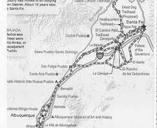
As the
caravans approached Santa Fe there were three clear choices: “one gave
travelers the choice of scaling the basalt behemoth [of La Bajada], another
followed the Santa Fe River through the yawning canyon of Las Bocas (the
Mouths), and the third required another, longer trek around La Bajada through
the Galisteo Basin,” according to the National Park Service web site.
It is that
third option that could cause the Royal Road to find its way through the Rancho
Viejo – possibly just up the street and a few feet into the desert plains from
our actual place of residence.
A major
reason for traveling through the Basin was the presence of the eponymous
Galisteo Creek – aka Galisteo River. (We
do like to overstate the size of few water sources that we have out here.) Santa Fe residents, and visitors such as
soldiers of both the U.S. Cavalry and the Confederate Army during the 1800s would
regularly water their horses, and themselves, at the perennial stream that
flows from the eastern highlands down into the Rio Grande through
Galisteo. I learned this during a
one-on-one meeting I was fortunate enough to have with Dr. Eric Blinman,
Director of the state’s Office of Archaeological Studies. I was asking him about possible historic and
prehistoric transients through the present day Rancho Viejo property. And he pointed out that it is a “straight
shot” from “The City Different” through Rancho Viejo to the Galisteo Creek.

One Rancho
that travelers on the Royal Road most definitely did pass through was what is
today El Rancho de las Golondrinas (The “Ranch of the Swallows”) – the living
history museum in La Cienega, NM at which Marsha and I volunteer. The first owner of record for this large
property was Miguel Vega y Coca who acquired the land in the early 1700s. For
many years y Coca’s estancia (literally “stay”) was a paraje (wayside camping
spot) on the Camino Real – providing goods for trade and serving as the last stop
for travelers heading north to Santa Fe, and the first for those on the
southbound journey to Mexico. The paraje
is mentioned explicitly by, among others, the Spanish military leader and
governor, Don Juan Bautista de Anza, who he stopped there with his
expeditionary force in 1780.
Rancho
Viejo’s part on the Royal Road does not have the same written documentation as
does The Ranch of the Swallows. But sometimes
all it takes for somewhere to be considered historically significant is for it to
geographically come between two genuinely historic locales that historic people
needed to travel between – the neighborhood shortcut (“barrio atajo”) that
everybody knows about, and uses.
That
certainly sounds like a “possibly could have” to me.