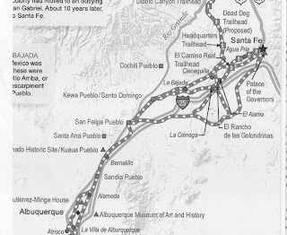
El Camino de Barrio Atajo – Was Rancho Viejo on The Camino Real?


For more than two centuries, from 1598 to 1882, the 1,600-mile long El Camino Real de Tierra Adentro [“The Royal Road of the Interior”] was the main line of communication and trade between the Spanish government in Mexico City and its distant frontier outpost of New Mexico and its Capital City of Santa Fe.  Literally everything the people of New Mexico needed that they could not produce themselves had to be transported over this vital link to the outside world.

             
So to have an historical connection, however tenuous, to this route without which New Mexico would not be what it is today – would be pretty cool.  So today’s question is, “Did El Camino Royal pass through what today is called Rancho Viejo?” – the 23,000-acre (39 square mile) parcel of land in southern Santa Fe County, which contains the HOA community in which Marsha and I now live.

             
A definite “yes” is what I am hoping for.  But I will certainly settle for a “possibly could have.” 


In 1582 Fray Bernardino Beltran and Antonio de Espejo led an expedition to New Mexico in search of Fray Agustin Rodrigues and his fellow priests who one year earlier had gone north from Mexico to explore the region traveled initially by Vasquez de Coronado in 1540.   Many of the priests of the 1581 odyssey were killed en route.  Fray Rodrigues and another cleric chose to stay to try and convert the Indians – but both disappeared and Beltran and Espejo failed to find any traces of either of them. The report of Beltran’s and Espejo’s travels is credited with the first official use of the term "La Nuevo Mexico" to describe the area – as well as being the first to enter this region with wagons.  In 1598, Don Juan de Onate followed these wheel tracks as he traveled northward to become Nuevo Mexico’s first governor in its initial capital at San Gabriel de Yungue-Ouinge, just west of present-day Ohkay Owingeh where the Rio Chama meets the Rio Grande.

            
 Robert J. Torrez writes on newmexicohistory.org,

             
“Every two or three years, a supply train composed of several dozen wagons loaded with supplies would head north towards Santa Fe, nearly sixteen-hundred miles away. These sturdy, four-wheel vehicles were pulled by teams of up to eight mules or oxen and carried food items that were not grown in New Mexico, including sugar and olive oil for cooking as well as welcome treats such as chocolate. Transportation of many other items of Spanish material culture, such as paper, cloth, shoes, medicine, musical instruments, barrels of sacramental wine, iron, gunpowder, and other supplies needed by the mission churches and the Spanish colonists, made the royal road an important factor in the survival of the colony.

             
“Finally, six months after leaving Mexico, the caravan arrived at Santa Fe. Anxious government officials would eagerly open leather pouches bulging with important government papers; local citizens, eager for news from home, would inquire about mail from loved ones; the wagons would be unloaded and the supplies distributed throughout the province. For the next four to six months, trade goods from the missions and settlements would be gathered in preparation for the return trip to Mexico. Vast flocks of sheep were collected; raw wool, buffalo and deer hides, pine nuts, salt, wool blankets, and woven stockings were carefully packed and loaded on the wagons. Soon the caravan would begin its long trip south, completing another cycle of trade and communication over the camino real—New Mexico's royal road.”

            
Over time the travelers of El Camino Real developed alternate sub-routes within the overall path.


As the caravans approached Santa Fe there were three clear choices: “one gave travelers the choice of scaling the basalt behemoth [of La Bajada], another followed the Santa Fe River through the yawning canyon of Las Bocas (the Mouths), and the third required another, longer trek around La Bajada through the Galisteo Basin,” according to the National Park Service web site.

             
It is that third option that could cause the Royal Road to find its way through the Rancho Viejo – possibly just up the street and a few feet into the desert plains from our actual place of residence.  

             
A major reason for traveling through the Basin was the presence of the eponymous Galisteo Creek – aka Galisteo River.  (We do like to overstate the size of few water sources that we have out here.)  Santa Fe residents, and visitors such as soldiers of both the U.S. Cavalry and the Confederate Army during the 1800s would regularly water their horses, and themselves, at the perennial stream that flows from the eastern highlands down into the Rio Grande through Galisteo.  I learned this during a one-on-one meeting I was fortunate enough to have with Dr. Eric Blinman, Director of the state’s Office of Archaeological Studies.  I was asking him about possible historic and prehistoric transients through the present day Rancho Viejo property.  And he pointed out that it is a “straight shot” from “The City Different” through Rancho Viejo to the Galisteo Creek.


One Rancho that travelers on the Royal Road most definitely did pass through was what is today El Rancho de las Golondrinas (The “Ranch of the Swallows”) – the living history museum in La Cienega, NM at which Marsha and I volunteer.  The first owner of record for this large property was Miguel Vega y Coca who acquired the land in the early 1700s. For many years y Coca’s estancia (literally “stay”) was a paraje (wayside camping spot) on the Camino Real – providing goods for trade and serving as the last stop for travelers heading north to Santa Fe, and the first for those on the southbound journey to Mexico.  The paraje is mentioned explicitly by, among others, the Spanish military leader and governor, Don Juan Bautista de Anza, who he stopped there with his expeditionary force in 1780.

            
Rancho Viejo’s part on the Royal Road does not have the same written documentation as does The Ranch of the Swallows.   But sometimes all it takes for somewhere to be considered historically significant is for it to geographically come between two genuinely historic locales that historic people needed to travel between – the neighborhood shortcut (“barrio atajo”) that everybody knows about, and uses. 

             
That certainly sounds like a “possibly could have” to me.


1600-1899 – "Unparalleled Land Stealing"


Prior to the Spanish settlement of Santa Fe in the 1600s, the territory in-and-around what is now Rancho Viejo was used for hunting and gathering, and occasionally occupied by what archaeologists call Paleoindians, Archaics, and Puebloans
           
The colonizing Spanish divided those open spaces into land grants.  (1) The majority of it was declared common land for the general support of the community.  (2) Some privately owned (“proprietary”) plots were awarded to favored subjects and loyalists of the Spanish government, Pueblo communities or families of ten or more, and “sito” or ranch grants ranging in size from one square league (nine square miles) to hundreds of thousands of acres were allocated to individuals and families.  And (3) some were declared royal or vacant lands, which also were used by the general populace. Unfortunately for historians and real estate lawyers, during the Pueblo Rebellion in 1680 – an uprising by the indigenous Pueblo people against their Spanish colonizers – the Palace of the Governors (built in 1610) containing records of many these early land grants was burned to the ground and many of the documents were destroyed.  

           
The situation was exacerbated between 1869 and 1871 when New Mexico Governor William Pile was in office.  According to newmexicohistory.org, “A major debacle occurring during Pile’s term concerned the territorial archives. Ira M. Bond, the territorial librarian who was an appointee and friend of the governor, sold and destroyed some of the archives of New Mexico. [Among them some of the land grant documentation.] This action was apparently taken at Pile’s suggestion, who wanted for office use the space occupied by archival material in the Palace of the Governors.  Pile was condemned at public meetings in Santa Fe and Albuquerque for this decision.”
           
Dr. Richard Melzer of UNM Valencia in a talk at El Rancho de las Golondrinas told his audience that among these documents were records of the early land grants.  When an effort was made to retrieve them it was found that many of them had been used as scraps to start fires, others in outhouses, and as butcher wrapping paper.
           
After Mexico won its independence from Spain in 1821 it continued the land grant laws with the one addition of allowing foreigners to acquire them – something not allowed by the Spanish.
           
After the Treaty of Guadalupe-Hidalgo, when the United States took over the New Mexican Territory, the land began to be further divided and titles reassigned –raising interesting questions about how the land came into Anglo ownership after Hispanic proprietorship – and if there were any legal shenanigans involved to transfer the right of possession.  Or as stated in “Windmills and Dreams” (a history of nearby Eldorado at Santa Fe), “unparalleled land stealing in New Mexico.”
           
Such as, the Native Pueblo Indians might say, had been done to them.
           
Spanish and Mexican land grants were officially protected under the Treaty of Guadalupe-Hidalgo – but this provision was not strictly enforced.  
           
William P Barrett writes in his online article “Who Owns New Mexico” that the Treaty “protected grant holders who had perfected their titles [all liens or other defects had been removed]. But the U.S. Senate refused to ratify a provision that would have vested grantees merely in the process of establishing that the claim was good and valid. Indeed, much of New Mexico's vast federal acreage today is the result of disallowed Mexican or Spanish land grants.  The result was decades of litigation--and fraud, as all kinds of dubious documents surfaced in purported support of these ancient rights.”
           
Inconsistencies between Anglo and Spanish land laws, indefinite land grant boundaries, and the inability of many claimants to provide proof of title led to legal and political entanglements and occasional violence in territorial New Mexico.  And the “Santa Fe Ring” – a group of powerful attorneys and land speculators (basically all the Republican politicians in the state capital during the late 19th and early 20th centuries – among them the aforementioned William Pile) – amassed a fortune through political corruption and fraudulent land deals.
           
Ultimately the Office of the United States Surveyor General for New Mexico was created in 1852 to investigate Spanish and Mexican land grants and recommend to the U.S. Congress those claims that had actual proof.
           
“Even so land grant issues remain vexing in New Mexico owing to the unfulfilled promise of the treaty of Guadalupe-Hidalgo,” wrote Stephen Sayles and Jerry L. Williams in discussion of Land Grants from “New Mexico in Maps” by UNM Press.
           
Eldorado at Santa Fe, the census-designated place to the west and somewhat south of Rancho Viejo has proof of being a part of both the then adjacent Lamy and Canada de Los Alamos Spanish Land Grants – with current day Eldorado taking up most of the former.  Windmills and Dreams, a history of Eldorado tells us, “Lorenzo Marquez was deeded the [Canada de Los Alamos] in 1785.  At that time, and until 1892, the grant was a basically square piece of property containing 13,700 acres.  It was bounded on the north by the main road from Pecos Cerrillos; on the west by a wooded ridge; on the south by Canada de la Tierra including the Colorado Mountains; and on the east the boundary line dropped due south from the junction of Old Las Vegas Highway and U.S. Highway 285 to a few miles north of the present town of Lamy.” 
           
The first owner of record of the Lamy Grant was Diego Antonio Baca who “sometime in 1807 was given the land in exchange for a house and lot to be used for barracks by government troops in the Presidio of Santa Fe.  The grant was described as being bounded: On the North, by the road leading from Santa Fe to Pecos; on the east by Cononcito de los Apaches, including the water of said canon; on the south by the road leading from Galisteo to its junction with the soldier’s bridle path; and on the west by the soldier’s bridle path and Cerro Colorado, including said Cerro.”

          
The next owner, circa 1817, was Carlos de Herrera, a sheepherder who had 500 consignment sheep stolen from him – and being unable to pay for the purloined ovines, devised a “back door” transfer of the property to the Catholic Church.   However selling land to the church was not allowed under Spanish or Mexican law.  So, “in order to clear up the situation”, in 1856 Bishop (later Archbishop) Jean Baptiste Lamy secured a quitclaim covering the grant from its heir Francisco Herrera.  “Lamy alleged that the will had been lost or misplaced; he also offered no explanations or apologies for his lack of documentation regarding the validity of the original Baca claim.”  Archbishop Lamy was the subject of Willa Cather’s novel “Death Comes to the Archbishop.”
          
A map of Spanish and Mexican Land Grants published in “New Mexico in Maps” shows the Lamy and Canada de Los Alamos grants as adjacent gray shapes in Southern Santa Fe Country ,with white space to the east and west and most of the south except for the relatively small (1,895 acres) San Marcos Pueblo Grant to the southwest, and the San Cristoval Grant attached to the southernmost extremity of the Lamy Grant.  Immediately north of Canada de Los Alamos is the Sebastian de Vargas Grant.
           
My interpretation of this diagrammatic representation is that the Spanish/Mexican origins of what is now Rancho Viejo lies in the white space to the east and south – indicating to me that the property was never privately granted land or, if it were, that any records of such grants do not exist.  The land may have been communal, Royal, or simply vacant.
           
Oh well – no Colonialism, in this case Spanish, in our property’s lineage.  But Marsha and I are used to such things being second generation Americans who moved to Santa Fe from Connecticut’s oldest incorporated town (1634) with a rich British Colonial history, and a significant number of residents with direct familial ties to that past.
           
But, on the plus side, now we don’t need to stay awake nights worrying about the ghost, or heirs, of Archbishop Lamy showing up at our door to reclaim their heritage.  The couple who live next door to us, however, are the Herreras, so…who knows.


An Additional Note:
           
A September 2001 Report to Congress “TREATY OF GUADALUPE HIDALGO – Definition and List of Community Land Grants in New Mexico reported the following:
           
“Land grant documents contain no direct reference to “community land grants” nor do Spanish and Mexican laws define or use this term. We did find, however, that some grants refer to lands set aside for general communal use (ejidos) or for specific purposes, including hunting (caza), pasture (pastos), wood gathering (leña), or watering (abrevederos). Scholars, the land grant literature, and popular terminology commonly use the phrase “community land grants” to denote land grants that set aside common lands for the use of the entire community. We adopted this broad definition in determining which Spanish and Mexican land grants can be identified as community land grants.
           
“We identified 154 community land grants (or approximately 52 percent) out of the total of 295 land grants in New Mexico. We divided these community land grants into three distinct types: 78 of these were grants in which the shared lands formed part of the grant according to the original grant documentation; 53 were grants that scholars, grantee heirs, or others believed to contain common lands; and 23 were grants extended to the
indigenous pueblo cultures in New Mexico.”

The Rancho Viejo HOAs – The Village

“In the United States, a homeowner association (HOA) is a private association formed by a real estate developer for the purpose of marketing, managing, and selling homes and lots in a residential subdivision. It grants the developer privileged voting rights in governing the association, while allowing the developer to exit financial and legal responsibility of the organization. Typically the developer will transfer ownership of the association to the homeowners after selling a predetermined number of lots. Generally any person who wants to buy a residence within the area of a homeowners association must become a member, and therefore must obey the governing documents including Articles of Incorporation, CC&Rs (Covenants, Conditions and Restrictions) and By-Laws, which may limit the owner's choices.” (Wikipedia.com)
           
In his self-published memoir, Larry Meyer (one of the five original owners Rancho Viejo Limited Partners – RVLP) writes, “Now that we had the ranch, we had to decide what we were going to do with it.  There were a number of things that had to be done, and neither Leland [Thompson] nor I really had the time or the knowledge.”    So the partnership hired John Dendahl, a third generation Santa Fean who had gone to college in Boulder Colorado with Meyer’s daughter Sharon to head-up the development effort.
             
But before that really got started however Meyer and Thompson became aware of the need for land on which to locate the newly established Santa Fe Community College – and they donated the 360 acres, which today is the institution’s campus.  (See Santa Fe Community College chapter).

(Santa Fe Community College logo)
             
Meyer’s memoir says, “Before donating the land, we had to extend the road and the water and gas lines.  Richards Avenue, a dirt road at the time, stopped about a quarter of a mile from the north boundary of the property that we were giving to the college.  We had to improve Richards from Rodeo Road south all the way to the site, 2 ½ miles, and bring it up to the city’s specifications so they could pave it…We also had to put in drainage culverts under the road, which should have been done by the property owners north of us.”
             
John Dendahl soon took a position as president of Santa Fe National Bank (at “four times what we were paying him for a half-time position.”)  Bob Lockwood, a general contractor with whom Meyer had worked in the past, offered to advise on the development of Rancho Viejo.  Lockwood was a paid advisor until 1996.
             
“Meanwhile Fred Chambers [another RVLP partner] thought there was a market for some small ranches down on the southwest corner of the property on Highway 14.”  RVLP allotted 1,600 acres for this “San Marcos” subdivision on which the Chapman Construction Company developed 99 lots with private wells ranging in size from ten-acres to one forty-acre tract.  In 2002 when Meyer published his memoir all but two of the original lots had been sold.  The subdivision is about two and one-half miles south of the Penitentiary of New Mexico on the west side of the Turquoise Trail.
             
Another venture was not quite so successful.
             
“Leland Thompson’s son Warren was working in real estate, and he found an investor who was interested in buying part of the ranch [3,000 acres] over near Eldorado.”  The investor was a Japanese firm called TSA – and in the late 80s and early 90s Japanese venture capitalists were buying a large number of properties across the United States.  However the Japanese economy began to deteriorate and the deal fell through.
             
“From that time on, plans to develop the ranch went from bad to worse…Warren brought in a couple of fellows from Palo Alto, California…who called themselves DOH International…They never mentioned any figures under a million dollars, but in fact [they] didn’t have a dime, figuratively.”
             
RVLP continued to donate land – nineteen acres to Santa Maria de la Paz Roman Catholic Church and Santo Nino School, ninety acres to the Institute of American Indian Arts, ten acres to The Academy for Technology and the Classics (ATC), 14.7 acres acres to the Amy Biehl Community School, 5 acres for the Seventh Day Adventist Church, 6.7 acres to Santa Maria El Mirador (Easter Seals), and a 2009 donation for the fire station on Rancho Viejo Blvd  (Please see “The Non-HOAs for Rancho Viejo.)
            
Also in 1993/94, Santa Fe County decided they wanted to put in their own water system for the whole county.  “The county was willing to sell some of the water, and Rancho Viejo and some of its neighbors agreed to buy these rights.”  Then the “neighbors” pulled out of the agreement and RVLP agreed to purchase the original amount of water (sixty-three acres) plus one hundred acre-feet more.
             
“Had we [RVLP] not done that, there probably wouldn’t be a county water system today.  We put up 51 percent of the total money they needed to get the county water system going and acquire most of the rights-of-way.”
             
Larry Meyer knew real estate developer Duane Black from work Black had done for Adeline and him in Mesa Arizona.  They later became close friends. When the real estate market collapsed in the late 80s, Duane Black had taken a job with SunCor, a subsidiary of the Electric Power Company of Arizona.  Around 1990 the two men had talked about Rancho Viejo and in 1994 Black brought RVLP and SunCor (as the developer) together and they put together a long-term plan to develop the entire Rancho in increments.  SunCor – a wholly owned subsidiary of Pinnacle West Capital Corp. and owner of Arizona Public Service (formerly Electric Power Company of Arizona) – then formed Rancho Viejo de Santa Fe Inc. to develop Rancho Viejo.  In 1995, 2,500 acres were sold to SunCor Development Company, which began developing the Village at Rancho Viejo under the name Rancho Viejo de Santa Fe, Inc.  Ultimately SunCor would build approximately 1,200 new residences at Rancho Viejo in the Village, Windmill Ridge, College Heights and the beginning of La Entrada.  In  2009, Pinnacle West’s board began a liquidation of SunCor, which ended in bankruptcy proceedings  in early 2013.
             
In late December 2010, Rancho Viejo Limited Partnership joined with Univest to form Univest-Rancho Viejo LLC. The company purchased the remaining land from SunCor, keeping the project out of bankruptcy.  Univest-Rancho Viejo continues the development of the project today.

According to builderonline.com’s December, 2003 article “Betting the Ranch” “’At the time SunCor entered into its agreement with the original landowner, there were a lot of skeptics about development in Santa Fe County,’ says Joe Porter, a principal at Design Workshop, a land planning, landscape architecture, and urban design firm based in Denver. ‘There was sprawl and a resource-consuming development pattern that nobody really liked, and I don't think the city [of Santa Fe] or anyone trusted the county to come up with a plan to manage this growth. Within the environmental community, Rancho Viejo had become the poster child for sprawl, or at least that was the fear.’”     
            
 Santa Fe residents in general rejected the idea of developing vacant or under-used parcels within the city (“infill development”) – yet were indifferent to suburban development in the area.
            
 “In 1997, SunCor and Design Workshop began informal talks with Santa Fe County planners about how to change the pattern of sprawl and found that they had some principles in common. These included protecting the visual and environmental values of the land; clustering development in traditional New Mexican settlements or villages; offering affordable housing and jobs for locals; providing adequate water; and helping establish an ongoing community-development process that would provide an alternative to sprawl.”
             
Eighteen months of talks involving county and city government, SunCor officials, Design Workshop planners, landowners, utilities, and local institutions resulted in a 17,000 acre Community College District Plan that codified a number of these common principles including a commitment to offer fifteen percent affordable houses to be integrated within the communities.
             
“As a way to demonstrate its commitment to the region's new land-use guidelines, SunCor created what was essentially a 350-unit demonstration village at Rancho Viejo, which is located within the Community College District. ‘The first village was designed to stand on its own if everything fell apart and there were no long-term approvals,’ says Porter. "We wanted to create more of a clustered village pattern that preserved open space. It was a way to demonstrate that we could all walk our talk.”
             
According to builderonline.com, “Cutting-edge financial considerations are also in play at Ranch Viejo. Rather than buying the land outright, SunCor pays the original landowners (a group called the Rancho Viejo Limited Partnership) a percentage of each unit that is constructed. When SunCor closes on a home, a check is written to the Partnership; the amount of each check is spelled out in the agreement and is based on land value. The new homeowner then owns the land.”
             
The project was begun in 1998, and in the year 2000 The Village was offering houses that began at $125,000 – In Larry Meyer’s words, ”a real bargain compared with the prices of most houses in town.”
            
 The 1999 “Rancho Viejo Landscape Vision – Home Owner’s Manual” for The Village tells the reader:  “The vision for the open space and built landscape for the Rancho Viejo community is one that embraces the surrounding natural landscape as the foundation for design.  Rancho Viejo’s vision is to synthesize key principals of ecological planning and sustainable design.  A significant effort has been made to reduce Rancho Viejo’s footprint on the land and environment.”
             
And in the Portfolio section of their website Design Workshop described the realization of that vision.
            
“The Rancho Viejo Community in Santa Fe County, New Mexico demonstrates the application of environmental, economic, community and aesthetic values. Recent development trends in Santa Fe have strayed from the traditional settlement pattern intrinsic to its character. In an effort to reduce suburban sprawl and preserve the region’s beauty, the landscape architect worked in collaboration with government, developer and citizens to produce this mixed-use community. This clustered village applies low-impact design practices of water conservation, preserves wildlife habitat and connects pedestrians to surrounding preserved open space.”
             
As a result of this philosophy Design Workshop says that Rancho Viejo:          
             
“Sustains all public landscaping through treated, seasonally stored grey water effluent (approximately 140,000 gallons per day).
             
“Reduced irrigation water consumption by 50%. As a result, the community received an additional 184 lots of development rights from the City of Santa Fe at a 20% increase in density beyond current water rights, allowing an additional $3 million in development.
             
“50% of open space is conserved as aquifer recharge through cluster development limited to high flat plains.
             
“Donated over 600 acres of community land to support five private, strategically placed educational institutions: Santo Nino Regional Catholic School (pre K-6), Amy Biehl Community School (K-6), Academy for Technology and the Classics (7-12), Santa Fe Community College, and the Institute of American Indian Art (Associates and Bachelor’s degrees).
             
“Over 15 miles of paved community trails that form critical transportation connections to established city and county trails.
             
“Approved the master plan and enabled the project to sell 9,000 acres successfully.
             
“Holistic water conservation plan designates limited turf areas to high use public areas, uses native plant materials, and preserves existing vegetation.
              
“Stormwater is managed through multiple sustainable features including: micro retention berms in streetscape; gabions for sediment control and increased percolation in drainage ways; check dams or hay bale dams to increase water harvesting and reduce erosion in swales; parallel swales within park areas to spread water catchment; and detention basins with riparian plantings for sediment control.
             
“Strategically placed lots take advantage of solar orientation and visual amenities.”
             
In 2003 Mountain Living Magazine ASLA, Colorado Chapter, presented Design Workshop and Rancho Viejo with the Responsible Development Award in Community Design, and Honor Award and Land Stewardship for Planning for “Respecting and building upon concepts from traditional New Mexico towns and plazas, integrating neighborhoods. The 21,000-acre development included a presence in the village center planning process, urban and village design, streetscape design down to residential design guidelines (empowering homeowners to customize their property).”
             
Popular reaction to The Village was however not all positive.  A 2004 article by George Johnson in “The Santa Fe Review A Journal of Commentary and Reportage” copyright 2004 described “row after row of brown stucco houses, packed cheek to jowl on a tight grid of tiny lots crisscrossed by narrow streets…Islands of open space, Suncor promises, will periodically interrupt the sprawl. But no matter how the copywriters describe it, what is on the drawing boards is nothing less than another city, to be grafted onto Santa Fe.”
             
However Ike Pino, a former Santa Fe city manager and, at that time, Rancho Viejo's general manager sees a different picture.  "The large areas of open space, landscape treatments, and architectural features are things that Joe Six Pack is not even familiar with, but they've all been calculated to make him feel good the minute he drives into the community. Having those values translated into requirements of the College District has served us well in terms of our ambiance and our ability to sell homes."


And demand for residences in The Village was high – as reported by Tom Sharpe in the August 27, 2000 Santa Fe New Mexican, “A half dozen people spent Friday night outside the sales office of The Village at Rancho Viejo so they could be sure to get a crack at eight new homes for sale at below-average prices.”


 The eight new “plaza homes” were priced from $125,000 to 156,000 – well below the Santa Fe median.

             
“Sleeping bags, pillows, lawn chairs and thermoses of coffee were left on the office’s desks at midmorning while the campers toured the model homes.”
             
Patrick Tomas, Qualified Broker said that 200 of the 300 units had been sold.
             
The article closed by describing Rancho Viejo as “a sprawling ranch south of Santa Fe that, if fully developed, could hold as many people [61,000] as Santa Fe does today.”
             
However, it being the desert southwest, there was that water thing as the Santa Fe new Mexican reported on August 1, 2001. 
             
Rancho Viejo’s ‘existing contract with Santa Fe County for 168 acre-feet of water could support development of about 672 houses.  The company needs to find other sources for water for the more than 11,000 houses it intends to build” – 12,000 units on 11,000 acres in the next forty years according to the New Mexican.
             
For which Rancho Viejo had a partial solution as described four days later in an August 5, 2001 Santa Fe New Mexican Op Ed column.
             
“For years Ranch Viejo meant little more than a name on a map of greater Santa Fe, a 30-square-mile stretch of cholla, grass and juniper south of Interstate 25 for which its owners had increasingly well-crafted plans.
             
“Symbolic of the growth-guiding challenges to our county government [Rancho Viejo suggested a joint venture] injecting treated sewer water into the ground raising the water table.” 
             
State Engineer Tom Turney declined the offer.  However as described in the chapter “Water and Housing”, things have changed.
             
And on the other side of the Viejo was water and housing problem, Rancho Viejo was being accused by County Commissioner Jack Sullivan of not “having kept up with their affordable housing agreements” as detailed in the Santa Fe Community College District plan  RV “is required to devote 15 percent of the homes allowed within its master plan to affordable housing.  Three income ranges are targeted and 5 percent of the required 15 percent of homes are devoted to each target range.  Affordable housing units are required to be integrated through out the development to promote diverse neighborhoods.”

Rancho Viejo contended that it was only eleven units behind that mark but the commission expressed concern that the developer might have to build “one large section of affordable houses at once” rather than integrating them into the community as promised.
             
 
By 2001 the original Rancho Viejo partners (Leland Thompson, Bill Kennedy, Fred Chambers, Adeline and Larry Meyer) had passed their various interests along to their children.
            
 And Larry Meyer reflected, “sitting here 20 years after we bought Rancho Viejo/, it finally looks like it’s going to be a prudent investment.  The bottom line about the partnership?  Yes, there was a lot of anxiety.  However that’s now behind us, and we’re proceeding very nicely.  As I say, Rancho Viejo has been a real success, thanks to SunCor and their excellent management team.”


The Rancho Viejo HOAs – Windmill Ridge

The development of The Village at Rancho Viejo was completed in 2010.  However, due to the 2008 economic crash, Pinnacle West decided to divest its interest in the real estate development business and liquidate all of its landholdings under development.
             
In order to save Rancho Viejo, RVLP entered into a partnership with Univest, a Phoenix investment and development company to form Univest-Rancho Viejo LLC which completed the purchase of Rancho Viejo from SunCor in December 2010.   Univest-Rancho Viejo LLC also owns Ranchland Utility Company, Estancia Homes, LLC, and Rancho Viejo Properties, LLC.  RVLP and Warren Thompson (son of Leland Thompson, one of the original Rancho Viejo partners) owns an interest in Univest-Rancho Viejo LLC.  In February 2012, SunCor filed for bankruptcy. 
             
As reported in the February 2011 Rancho Viejo South Newsletter:
            
 “The future of Rancho Viejo now rests with its past. The remaining development rights as well as the home-building business, architectural plans and infrastructure have been purchased by the same family partnership that first subdivided the area in the 1990s.
             
“The new partnership is called Univest-Rancho Viejo LLC, which closed on the purchase from SunCor in December 2010. SunCor will still service home warranties for perhaps 100 properties.  ‘Warren Thompson, whose father ranched in what is now the 1,200 home Rancho Viejo subdivision, is a principal partner in the new business, which includes a small group of other families,’ said Patrick Thomas, Qualifying Broker for Rancho Viejo Properties LLC. ‘We now believe that we have a uniquely qualified team to lead the community forward,’ Thomas said. The sale includes Ranchland Utility, the sewer system that serves the homes, businesses and schools as well as the 456 approved and platted [mapped out] lots in La Entrada, where 115 homes have now been built. Other platted lots scattered throughout Windmill Ridge were also transferred, said Thomas and any construction on those lots rests with the new company.  In all, the family partnership owns some 22,000 acres that will be managed under Univest-Rancho Viejo with Tom Lowe as the founding partner.          
             
“The sale does not include the commercial building [in The Village]e, which is privately held, while trails, parks, plaza and open space remain the property of the North and South HOAs. The sale also brings to a close the transition issues of the South Association. SunCor paid the South HOA $150,000 to cover future costs related to its common areas and infrastructure.
             
“Q&A: Warren Thompson  By Lee Lefton
             
“Recently, I had an opportunity to speak with one of the new owners, Warren Thompson, about the history and recent purchase of Rancho Viejo.
             
“Q: How & when did Rancho Viejo start?
             
“A: Back in 1981, my father, Leland Thompson, Jr. and three of his friends set up The Rancho Viejo Partners, LLC, and bought the Jarrott Ranch from the estate of Bernice Jarrott Lord. In 1996, the land sold to SunCor, Inc. 
            
 “Q: What company bought Rancho Viejo from SunCor?
             
“A: Univest-Rancho Viejo LLC, a real estate development company made up of a group of original Santa Fe landowners and principals of Scotts- dale, Arizona-based Univest.
             
“Q: What is their vision?
            
 “A: Rancho Viejo is an outstanding property. We want to see it grow while maintaining the tradition of community that fulfills the desires of current and future residents.
             
“Q:   Who will be handling new home sales?
             
“A: A new, local firm, Rancho Viejo Realty Co. A separate homebuilding company, Estancia Homes LLC, will be on-site at the community.
             
“Q:   Will the existing staff stay part of that team?
             
“A: Yes. We want to maintain continuity. Patrick Thomas, the Qualifying Broker for the past eleven years, will remain in that role for the new company.
             
“Q: What are you doing now?
             
“A:  Sailing in the Caribbean.” 
             
According to a January 19, 2011 Santa Fe New Mexican article, “The development has some 1,200 homes as well as parks, playing fields and a central plaza. There are three separate homeowner associations that own all of development's open spaces, recreational areas and six-plus miles of trails. These areas are not included in the transaction.”
             
Bruno Keller, president of the Rancho Viejo North Homeowners Association is quoted as saying "We hope some of the past plans as presented to us now will be completed by the new owner."
             
The article went on to report that although home sales have slowed in recent years nationally Rancho Viejo still had forty-one sales of new homes in 2010.
           
The August 2014 Rancho Viejo South Newsletter reported:
             
“Univest-Rancho Viejo LLC is restarting the development of Rancho Viejo begun by the previous developer, SunCor Inc.  Changes that occurred during the later stages of SunCor’s tenure, the ultimate liquidation of SunCor and the Rancho Viejo property by Pinnacle West Capital Corporation, and problems with the restart process have collectively been a major shock to Rancho Viejo’s development and have created considerable frustration for Rancho Viejo residents.”
             
And in the December 2014 Issue of the Rancho Viejo Round Up newsletter the “What’s Happening at the Rancho Viejo Sales Office” column announced “WE ARE EXCITED to announce that Rancho Viejo Properties has recently sold out of developed production lots in Windmill Ridge Phase IV, with the final completion of homes expected March, 2015. We have released 41 new lots in La Entrada to continue the completion of La Entrada Phase One.  To date, we have closed a combined total of 31 homes in Windmill Ridge and La Entrada with a couple more closings by end of 2014.We will continue to build through the Holiday season as we have 12 new homes on the books for 2015. Seven of those homes yet to be built will be in La Entrada.”
             
The same newsletter also reported that according to the Santa Fe County Sheriff’s office that Rancho Viejo was the safest community in the county.


Sources:


So What About the Windmill?


“After a day’s work, as I rested on the porch steps in the fading daylight, I could hear the sucker rods of the old wooden windmill lifting water.” (Etchings on the Heart by Susan A. Holland in New Mexico Magazine, February 2018)
             
“The unglamorous, squeaking windmill … was the one machine without which the Plains settlers could not have hoped for survival. For the one essential the plainsmen didn’t have was water; the windmill often was the easiest and sometimes was the only way that the precious water could be obtained. Now the windmills are disappearing from the scene—gradually, but surely. … As long as their dwindling numbers stand, the sturdy old powerhouses of the Plains remain as evidence enough that it was not flying lead but the flying wheels of the windmills that did the most to truly win the West.  Jeff Grooms in New Mexico Magazine, March 2018)

Rancho Viejo at Santa Fe, where Marsha and I now live, is divided into three Home Owner Associations: Entrada, South Community (“Windmill Ridge”), and North Community (“The Village”).  Even though our home is in North Rancho Viejo the south Community’s windmill is clearly visible to us every day as we walk the desert trails – as a result the first question that we had when we moved here in September 2017 was, “so what about the windmill?”    
             
In his self-published book “The Memoirs of Larry Meyer” one of the original owners of Rancho Viejo recalls their major problem in developing the land, “First of all there was no water on the property – only several windmills – so if we were going to develop it, we had to find water.” 
             
Unbeknownst to this city-born-and-raised/suburban adult northeasterner, there were apparently parts of the United States that did not have the luxury of municipally supplied water.  Hence the now landmark symbol of and eponymous name source for our neighboring HOA community to the south.
             
Actually a form of water pump, windmills in the southwest were once a necessary way of supplying “Adam’s ale” for cattle and crop irrigation, but were largely abandoned when electric and gasoline motors came on the scene.  “Early documents refer to use of windmills…in Persia in 644 A.D.” were they were used to “grind grain” according to the book “Windmills and Dreams”.  They appeared in Europe in the 12th century.
             
On August 29, 1854, Daniel Halladay a machinist, inventor, and businessman from Connecticut patented the first commercially viable windmill – “Halladay’s Self-Governing Windmill” – after having been approached to work on the design by Ellington, Connecticut businessman, John Burnham. Burnham was in the pump business and realized that with a reliable way to bring ground water to the surface he could significantly increase business.  “Halladay’s Self-Governing Windmill” automatically turned to face the prevailing wind direction, and maintained a uniform speed by changing the pitch of the sails – with no human oversight.  The device would stand still during a storm by turning the edges of its sail wings to face into the wind, and then gradually redeploy them to resume operation when the storm ended.  It successfully drew water from as deep and twenty-five feet and moved it more than 100 feet into a reservoir.   The windmill itself sold for $50.00, with pumps and pipes costing an additional $25.00.  Halladay later moved his business to be closer to his western customer, forming the U.S. Wind Engine and Pipe Company of Batavia, Illinois.
             
Another highly successful brand of water pumping windmills for the southwest was the “Eclipse” produced by Morse and Company and invented by Leonard Wheeler, a Presbyterian minister who was working among the Ojibwe Indians on the south shore of Lake Superior.  He perfected the device in the privacy of his missionary homestead using it to draw water for his house for nearly two decades.  In 1866 ill health forced him to return to his hometown of Beloit, Wisconsin and seek a different career.  A cousin of his, Samuel Shipman, convinced him to patent the machine (US Patent No, 68674).  The “Eclipse” used a secondary vane, which shifted angles, and was held in position by weights through a series of pulleys to keep the windmill pointed at the optimum angle at all times.  The galvanized steel tower stood thirty feet tall with a six foot in diameter steel wheel.  The original Montgomery Ward Company (1872 – 2001) – a dry goods mail-order business out of Chicago Illinois distributed the machine.

          
Wheeler’s windmill was initially manufactured by L.H. Wheeler and Sons and was exhibited at the Centennial International Exhibition of 1876, the first official World's Fair in the United States, in Philadelphia, Pennsylvania along with Halladay’s Self-Governing Windmill, and two other companies.  Charles Morse later purchased an interest in the company and merged it with Fairbanks Company to form Fairbanks, Morse & Co.  Morse asserted the reasons for the machine’s success as:

1.     “windmills could be shipped in pieces and yet assembled and erected with simple tools by people of ordinary ability;
2.     their parts were interchangeable, and thus repair were simple;
3.     windmills were made from durable materials; proper wood painted for protection and steel which had been protected by galvanizing;
4.     a minimum amount of material was used, cost of raw materials, transportation, and erection was kept at an economical level;
5.     lubrication problems were solved after the introduction of the self-principle early in this century; and;
6.     finally, and perhaps most importantly, the American were self-governing.”
             
These windmills allowed ranchers in New Mexico to graze their cattle over many square miles of the arid high desert land.  In the Santa Fe area cattle farms such as the old Lamy/Simpson Ranch and others used the technology – dotting the landscape with the tall, gawky, feathered water pumps.  Several of these machines survive today: to the west of Casa del Oro; near the old Pueblo Indian sites on the Simpson property; near Lamy; in the vicinity of St. Vincent Hospital; close to the Wheelwright Museum; going north on I-25 to the southwest; visible in the distance on the drive along The Turquoise Trail; behind the Guadalupe Credit Union on Mimbres lane off of Rodeo Road; one just after the arroyo crossing on Los Pinos Road (the road to El Rancho de las Golondrinas); and on the grounds of the San Marcos Seed Store and Café on Route 14; and one, believed to be an Eclipse, that is still operating in Eldorado just outside the second entrance and across U.S. Highway 285 from Avenida Vista Grande.
             
In a 1997 interview for the book “Windmills and Dreams – A History of the Eldorado Community and Neighboring Areas” Robert Dobyn recalled his summers visiting at the Lamy Ranch on the property that is now Eldorado.
              
“Water was always a problem here….you know where they have the Old Ranch Road and the art barns of U.S. 285, right behind the dump – there are two wells back there…We used to have windmills on that.  When you had windmills and you were running cattle, back in ’72, you were allotted commercial water rights, and that’s where AMREP [the initial Eldorado developer] got their water.  They consolidated all the windmills, and obviously they weren’t going to use the windmills…
             
“Where my parents lived in downtown Santa Fe, we had a windmill.  It’s still [1997] there.  Windmills were real common.  There’s a ton of them.  This one is on Old Santa Fe Trail by Kaune’s [Market], where I was raised…The windmill operates on the suction principle.  Basically it’s a piece of pipe with what you call “leathers”, and the leathers swell and suction around the pipe.  The leathers wear out and you have to replace them.  That means you have to pull the pipes out, and that a lot of work, and we’d have to do that (on the ranch).  That’s how the cattle depended on water.  We’d build natural holding tanks in the arroyos (as well).”
             
The Rancho Viejo windmill is located at the corner of Saddleback Mesa and Mineral Hill, and was manufactured by the Aeromotor Windmill Company of Chicago, Illinois.  The company is still in business, now located in San Angelo, Texas.  

             
The Aeromotor was first developed in 1883 by a mechanical and civil engineer named Thomas O. Perry who (according to the company’s website) “had previously worked for U.S. Wind Engine Company, of Batavia, Illinois, and had conducted over 5,000 scientific tests on 61 different experimental wind wheels. These tests had been meticulously conducted indoors under controlled conditions, by mounting 5 ft. diameter steel test wheels on a steam driven arm, which provided constant artificial wind. His best test wheel was 87% more efficient than the common wood wheels in use at the time.” The U. S. Wind Engine Company however showed no interest in utilizing Perry’s discoveries. But LaVerne Noyes, a Chicago manufacturer of dictionary stands and farm equipment, recognized the potential and encouraged Perry to develop this “truly scientific steel windmill.”

             
Derisively called the “mathematical windmill” by its competitors Aeromotor sold only twenty-four windmills in 1888, its first year.  In 1892 they sold 20,000 of the machines, and “Aermotor was on its way to becoming the world’s dominant windmill.”
             
Because in most cases these devices shipped to rural locations in the southwest where they were assembled and put into operation by their owners, the manufacturers do not have detailed records of their locations.  Thus, I have not been able to find any other information about the Windmill Ridge landmark.
             
I believe it can be fairly said that the self-governing windmill was a major factor in how the west was won.  Although the mill at Rancho Viejo no longer pumps water – the sound of the sucker rod’s up-and-down motion and rotating metal blades can still be heard, reminding us of the role these devices played in Rancho Viejo’s, and New Mexico’s, history.


How a Windmill Pumps Water
            The water-pumping windmill is a simple, efficient design.
            The blades, also known as sails, of the windmill wheel catch the wind, which turns the rotor.
            The wheel assembly is attached to a hub assembly by long arms.
            The hub assembly drives a geared mechanism that converts rotary motion to an up-and-down motion.
            That up-and-down motion drives a long sucker rod, also known as a pump rod, up and down inside of a pipe in the well.
            Attached to the end of the pipe is a cylinder with a sealed plunger going up and down inside that forces the water up the pipe.
            Each upstroke pulls water into the cylinder.
            On the downstroke, a check valve in the bottom won’t let the water be pushed out, so the water is forced up the pipe with the next upstroke.

Sources:
Windmills and Dreams: A History of the Eldorado Community; written and edited by Eldorado Volunteers; Eldorado Community Improvement Association
Connecticuthistory.org
Wikipedia.com
aermotorwindmill.com
The Memoirs of Larry Meyer; self-published; 2002